| Piú viste - The Moon through LRO |

LRO-M102215743LC-2-MF-LXTT.jpgOrbital View (2)106 visitenessun commentoMareKromium
|
|

LRO-M116628790RE-2-MF-LXTT.jpgJust a Mound or, maybe, a Remnant? (EDM n.2 - credits for add. process.: Dr Marco Faccin - Lunexit Team)106 visitenessun commentoMareKromium
|
|
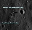
LRO-0003b-369440main_lroc_apollo11_lrg.jpgThe Apollo 11 Descent Stage and the "Mistery Cloud" (edm; credits: Lunar Explorer Italia)103 visiteA nostro parere non serve questionare - stupidamente - la realtà o meno delle Missioni Apollo per cercare "Mistero" (o "Complotto"...): guardate questo edm derivato dal frame precedente. Le ombre ci dicono tutto: altezze ipotetiche degli oggetti ripresi, inclinazioni, albedo etc.
L'ombra del Descent Stage dell'Apollo 11 è spettacolarmente chiara e va anche a dimostrare la correttezza della nostra ricostruzione (vecchia di 5 anni ormai) in ordine al motivo per cui alcuni frames Apollo 11 SEMBRAVANO presentare un orizzonte "tagliato".
E allora? Dov'è il "Mistero"?
Semplice: osservate il rilievo indicato dalla freccia e capirete. Visivamente si presenta come un piccolo "mound" - simile a quello prossimo all'area di Landing dell'Apollo 12 e fotografato più volte da Bean e Conrad - ma, in realtà, la sua texture lo rende simile ad una sorta di nuvola. Inoltre, se guardate con attenzione, noterete un'ombra incongrua fra il rilievo misterioso ed il cratere latistante.
Insomma: la Luna è vicina...Ma ancora ben lungi dall'essere pienamente compresa in tutte le sue sfaccettature e fenomenologie.MareKromium
|
|

LRO-0009-369230main_apollolandinglocator_full.jpgWhere did we go?!?102 visite...Un utile "Promemoria"...MareKromium
|
|

LRO-2000-eAGLE-WestCrater-00.jpgThe Lunar Module "Eagle", from LRO (CTX Frame - credits: NASA)101 visite...Due immagini (questa e l'EDM che segue) ASSOLUTAMENTE FANTASTICHE e da guardare, a nostro parere, non solo con Deferenza e grande Rispetto, ma anche dedicando, nel contempo, un pensiero ed una preghiara a coloro che, per realizzare questo Sogno, sono morti e poi sono anche stati - in larga misura - dimenticati (e NON ci riferiamo solamente agli Astronauti Americani, ma a TUTTI i Cosmonauti USA ed URSS i quali, negli Anni d'Oro della "Moon Quest" e poi in seguito, arrivando ai nostri giorni, hanno inseguito un Sogno ed hanno obbedito agli ordini, sino a compiere l'Estremo Sacrificio).MareKromium
|
|
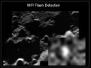
LRO-1010-392933main_LCROSS_5_full.jpgLCROSS impacting the Moon: the "Flash" in MIR Light100 visiteThis Mid-InfraRed (MIR) image was taken in the last minutes of the LCROSS flight mission to the Moon.
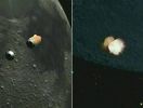
The small white spot (enlarged in the insets) seen within the dark shadow of lunar crater walls is the initial flash created by the impact of a spent Centaur upper stage rocket. Traveling at 1,5 mps (miles-per-second), the Centaur rocket hit the Lunar Surface yesterday at 04:31 UT, followed a few minutes later by the shepherding LCROSS Spacecraft.
Earthbound observatories have reported capturing both impacts. But before crashing into the Lunar Surface itself, the LCROSS Spacecraft's instrumentation successfully recorded close-up the details of the rocket stage impact, the resulting crater and debris cloud.
In the coming weeks, data from the challenging mission will be used to search for signs of water in the Lunar Material blasted from the Surface.MareKromium
|
|

LRO-M102215743LC-1-MF-LXTT.jpgOrbital View (1)97 visitenessun commentoMareKromium
|
|

LRO-0004a-369441main_lroc_apollo14_lrg.jpgFra Mauro: the Apollo 14 Landing Site (ctx frame)95 visitenessun commentoMareKromium
|
|

LRO-3003-Gruithuisen_Domes.pngGruithuisen Domes93 visitenessun commentoMareKromium
|
|
LRO-1009-Crash1.jpgLCROSS impacting the Moon92 visitenessun commentoMareKromium
|
|
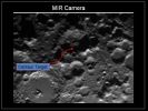
LRO-1014-392915main_LCROSS_3_full.jpgLCROSS Impact Location92 visiteLCROSS impact crater as seen with the Mid InfraRed (MIR) camera.MareKromium
|
|

LRO-2500-Bessel_Crater.jpgBessel (possible Natural Colors on a Radar Image; credits: Dr Paolo C. Fienga - Lunexit Team)92 visiteMini-RF S-band Zoom Synthetic Aperture Radar (SAR) image strip through central Mare Serenitatis on the Near-Side of the Moon (approx. Long. of the strip ~ 18° East; center Lat. ~ 20° North).
The radar strip runs through the crater Bessel (inset; approx. 15 km (or about 9 mile) diameter; center at 21,8° North Lat. and 17,9° East Long.) and covers the highlands of the Haemus Mountains (on the Rim of the Serenitatis Basin) in its Southern (bottom) third.
The full-resolution SAR data are 30 mt (90 feet). The Streaks of bright and dark material in the Walls of Bessel probably reflect the blockiness of Landslides within the Crater, brighter Streaks having more blocks of the 10-cm (4") scale.
The radar strip covers a major geological boundary in Mare Serenitatis; the darker, lower Maria has higher Titanium content than central Serenitatis. We see this geological boundary in the Mini-RF radar image, caused by higher absorption of RF energy by the high content of the Iron-Titanium Oxide mineral "Ilmenite".
Thus, Mini-RF SAR images can be used to map the Titanium content of the Lunar Maria. The background image is part of the Clementine global mosaic.MareKromium
|
|
| 69 immagini su 6 pagina(e) |
 |
3 | |
|
|








