| Piú votate - A Tribute To Mars Global Surveyor |

Craters-Unnamed_Crater_in_Noachis_Terra-PIA07202_modest.jpgUnnamed Crater in Noachis Terra (Original NASA/MGS/MSSS b/w Frame)95 visiteCaption NASA originale: "This Mars Global Surveyor (MGS) Mars Orbiter Camera (MOC) image shows an impact crater, a little over 2 Km (> 1,2 mi) in diameter, located in Noachis Terra near 50.4°S, 14.3°W. The crater's bouldery ejecta blanket has protected underlying material from being eroded away by wind, leaving the ejecta up on a low pedestal. This picture covers an area about 3 km (1.9 mi) across, and is illuminated by sunlight from the upper left".
(6 voti)
|
|

North_Polar_Features-Chasma_Boreale-PIA07195-00-PCF-LXTT.jpgFeatures of Chasma Boreale (Original NASA/MGS/MSSS b/w Frame) 111 visiteCaption NASA originale:"This Mars Global Surveyor (MGS) Mars Orbiter Camera (MOC) image shows dark Sand Dunes in the North Polar Region of Mars. They are streaming away (toward the left) from a low escarpment at the edge of an outlier of Polar Water Ice (the bright area on the right). The picture covers an area about 3 Km (1.9 mi) wide and is located near 80,7° North Lat. and 80,2° West Long.. Sunlight illuminates the scene from the lower left".
(6 voti)
|
|

Phobos_from_MGS-001.jpgPhobos from Mars Global Surveyor (2)277 visiteTra le idee che la NASA aveva in mente c'era anche quella di inviare una Sonda proprio su Phobos, onde studiarlo meglio ed eventualmente atterrarci sopra.
L'idea di uno studio maggiormente approfondito di questo corpo celeste è rimasta, ma le possibilità di un atterraggio sono sensibilmente diminuite da quando si è scoperto (grazie alla Sonda Mars Global Surveyor ed alle immagini scattate in infrarosso) che l'intera superficie di Phobos è ricoperta da uno strato uniforme di polvere spesso circa 1 metro!
(6 voti)
|
|

Craters-Rabe_Crater-PCF-LXTT.jpgOn the Floor of Rabe Crater (Absolute Natural Colors; credits for the additional process. and color: Dr Paolo C. Fienga - Lunexit Team)245 visiteCaption NASA originale:"This MGS-MOC image shows remnants — Buttes and Knobs — of light-toned rock, perhaps sedimentary in origin, on the Floor of Rabe Crater. The Buttes and Knobs are surrounded by dark, windblown Sands which have been criss-crossed by Dust Devil Tracks".
Location near: 44,0° South; 325,9° West
Image width: ~3 Km (~1,9 mi)
Illumination from: upper left
Season: Southern SummerMareKromium
(5 voti)
|
|
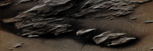
Volcanic_Regions-Rocky_Outcrops-MGS-01.jpgStreamlined Rocky Outcrops near Olympus Mons (Enhanced Absolute Natural Colors; credits for the additional process. and color.: Dr Paolo C. Fienga - Lunar Explorer Italia) 256 visiteCaption NASA originale:"This MGS-MOC image shows wind-eroded "Streamlined" Rocky Outcrops overlying Lava Flow Surfaces located to the West of Olympus Mons. Outcrops with this appearance are also called Yardangs.
Yardangs typically form in Sedimentary Rock or Volcanic Ash that contains some amount of Sand. The weathering of the Rock due to the Aeolian action cause the release of sand-sized particles from the Outcrops and, in time, such a form of erosion slowly shape the rock into the classic, inverted boat hull-like shapes of Yardangs".
Location near: 13,2° North Lat. and 160,1° West Long.
Image width: ~3 Km (~1,9 mi)
Illumination from: lower left
Season: Northern SpringMareKromium
(5 voti)
|
|

Channels-Unnamed_Channel_in_Stygis_Catena-PIA07133-01.jpgAncient Riverbed in Stygis Catena (Absolute Natural Colors; credits for the additional process. and color.: Dr Paolo C. Fienga - Lunexit Team)178 visiteCaption NASA originale:"This MGS-MOC image shows a Trough (Trough ---> canale) in the Stygis Catena Region, East of the Martian Volcano Elysium Mons. The Trough probably formed by collapse (Collapse ---> geol. "cedimento" del terreno). Large, dark Boulders can be seen on the Trough Floor in this Volcanic Region. The image is located near 24,4° North Lat. and 210,4° West Long. The image covers an area about 3 km (approx. 1,9 mi) wide and sunlight illuminates the scene from the lower left".MareKromium
(5 voti)
|
|

Channels-Unnamed_Channel_near_Cydonia_Region-PIA07272-01.jpgArabia Terra, near Cydonia Region: the "Sphynx" River (Absolute Natural Colors; credits for the additional process. and color.: Dr Paolo C. Fienga - Lunexit Team) 175 visitenessun commentoMareKromium
(5 voti)
|
|

North_Polar_Features-North_Polar_Scarp-MGS-01.jpgNorth Polar Panorama (Absolute Natural Colors; credits for the additional process. and color.: Dr Paolo C. Fienga - Lunexit Team)184 visiteCaption NASA originale:"This MGS-MOC image shows a steep slope in the North Polar Region of Mars. The stripes indicate an exposure of layered material; the variations in brightness among the stripes are the result of varying amounts and textures on seasonal Carbon Dioxide (CO2) frost. At the time the image was acquired - such as in June 2006 -, the Carbon Dioxide frost was beginning to sublime way, leaving a variety of different patterns in frost distribution".
Location near: 85,2° North Lat. and 122,7° West Long.
Image width: ~3 Km (~1,9 mi)
Illumination from: lower left
Season: Northern Spring MareKromium
(5 voti)
|
|

South_Polar_Regions-M0903484-01.jpgFeatures of the South Polar Regions (CTX Frame - Absolute Natural Colors; credits for the additional process. and color.: Dr Paolo C. Fienga - Lunexit Team) 200 visitenessun commentoMareKromium
(5 voti)
|
|

South_Polar_Regions-M0903484-03.jpgFeatures of the South Polar Regions (EDM - Absolute Natural Colors; credits for the additional process. and color.: Dr Paolo C. Fienga - Lunexit Team) 198 visitenessun commentoMareKromium
(5 voti)
|
|
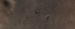
Aeolian_Features-Dust_Devil-MGS-02.jpgRunning Winds... (Absolute Natural Colors; credits for the additional process. and color.: Dr Paolo C. Fienga - Lunexit Team)215 visitenessun commentoMareKromium
(5 voti)
|
|

Aeolian_Features-Windstreaks-Chrise_Planitia-MGS-01.jpgWindstreaks in Chryse Planitia (Natural Colors; credits for the additional process. and color.: Dr Paolo C. Fienga - Lunexit Team)203 visiteCaption NASA originale:"This MGS-MOC image shows two Unnamed Impact Craters of nearly equal size, plus their associated Windstreaks. These occur in far Eastern Chryse Planitia. The Wind streaks point toward the South-West, indicating that the responsible Winds blew from the North-East. One of the two craters is shallower than the other and has a suite of large, windblown Ripples on its Floor. The shallower Unnamed Crater with the Ripples is probably older than the other, deeper Unnamed Crater".
Location near: 20,6° North Lat. and 30,1° West Long.
Image width: ~3 Km (~1,9 mi)
Illumination from: lower left
Season: Northern Winter MareKromium
(5 voti)
|
|
| 512 immagini su 43 pagina(e) |
 |
|
|
|
|
24 | |
|
|
|
|








