| Piú votate - A Tribute To Mars Global Surveyor |

Chaotic_Terrain-Aram_Chaos-S0100839-PCF-LXTT-01.jpgUnusual Surface Features in Aram Chaos (EDM - False Colors)69 visiteRilievo n. 1: il "Triangolo Isoscele". Probabilmente un'ombra o (più verosimilmente) un collapse pit o, comunque, un'area depressa: l'immagine MGS è, purtroppo, di qualità molto scarsa ed i nostri tentativi di migliorarla sono inevitabilmente produttivi di image-artifacts i quali, alla fine, confondono ancora di più le idee. Comunque sia, non abbiamo elementi per congetturare una possibile origine "non naturale" del dettaglio;
Rilievo n. 2: le (gigantesche, dato che risultano visibili da grandi altezze) "Dune Rigide" (o "Ripples") che attraversano questa Regione, come ben si vede nel frame in oggetto (ed anche senza magnificarlo), vista la facilità che hanno nel passare da aree "piatte" ad aree "elevate" rispetto al Datum" (modeste colline o dossi, ad esempio) senza modificare la loro struttura - sostanzialmente liscia e lineare -, diremmo che assomigliano di più a dei veri e propri "ponti" (i famosi "Bridges of Aram Chaos", dopo quelli di Becquerel Crater, se volete), piuttosto che a meri accumuli di sabbie e polveri dapprima rappresi (dal freddo) e poi modellati (scolpiti) dall'azione dei Venti Marziani.
Ponti, ovviamente, di origine assolutamente naturale ma di matrice "discutibile"...;
Rilievo n. 3: un "ponte" ricurvo e ad albedo elevata, COMPLETAMENTE incongruo rispetto al panorama al quale accede (per la NASA, si ribadisce, si tratta sempre e solo di Ripples, ma NESSUNO - alla NASA... - ha spiegato come delle semplici Dune Rigide potrebbero arrivare a configurarsi in questo modo...);
Rilievo n. 4: un altro "ponte" ricurvo e ad albedo elevatissima che sembra "emergere" dal sottosuolo e sulla cui origine si potrebbe discutere (restando "a tavolino") per un secolo e mezzo senza arrivare assolutamente a nulla.
Morale: la Regione di Aram Chaos (e qui l'attribuzione della caratterizzazione "Chaos" ci appare quanto mai appropriata) costituisce un autentico Paradiso di (possibili) Anomalìe.
Ma la domanda essenziale (che rivolgiamo a noi stessi ed a Voi) era ed è sempre la stessa ed è solo una: quali di queste possibili Anomalìe sono effettivamente tali e quante, invece, sono il prodotto di illusioni ottiche determinate dalla distanza e dall'angolo di ripresa?
Il che vuol dire, in breve: prima di provare anche solo a domandarci "che Natura potrebbe avere il rilievo che vediamo?", è sempre meglio cercare di capire se esso ESISTE DAVVERO oppure se si tratta solo del prodotto di un inganno ottico determinato da elementi oggettivi, reali e, per l'Osservatore, insormontabili (altezza, angolo slant del particolare ripreso, condizioni di illuminazione locale, risoluzione e definizione del frame etc.).
Tutto ciò premesso, agendo sulla base della nostra competenza ed esperienza, possiamo dire questo: la Regione di Aram Chaos presenta, effettivamente, delle Caratterizzazioni Locali ASSOLUTAMENTE peculiari e di difficile (o impossibile) spiegazione. Si potrebbe trattare di molte cose diverse ed eccezionali, oppure di nulla di speciale: noi non lo sappiamo. Quello che sappiamo, è che solo l'analisi pragmatica e razionale (e NON pre-orientata) dei dati - ivi: le immagini - ci può aiutare a capire qualcosa di quello che osserviamo.
Ma la certezza (QUALSIASI certezza) potrà arrivare solo andando in loco.
Operando al di fuori di questo "range di razionalità" - credeteci - si "naviga a vista" in un oceano di congetture, illazioni, speculazioni e bufale vere e proprie (e che Hoagland & Compagnia Bella ci perdonino...).MareKromium
(6 voti)
|
|

00-A-Mars_Global_Surveyor.jpgMars Global Surveyor74 visiteMars Global Surveyor was launched in 1996 on a mission designed to study Mars from orbit for two years. It accomplished many important discoveries during nine years in orbit. On Nov. 2, 2006, the spacecraft transmitted information that one of its arrays (---> pannelli) was not pivoting (--> ruotando) as commanded.
Loss of signal from the MGS Orbiter began on the following orbit.
Mars Global Surveyor has operated longer at Mars than any other spacecraft in history and for more than four times as long as the prime mission originally planned.
NASA has recently formed an internal review board to look more in-depth into why NASA's Mars Global Surveyor went silent in November 2006 and recommend any processes or procedures that could increase safety for other spacecraft.
(6 voti)
|
|

Troughs-Tharsis_Region-PIA04103-001.jpgWhat's inside the Trough? (EDM n.1- Enhanced Natural Colors; credits for the additional process. and color.: Dr Paolo C. Fienga - Lunexit Team)66 visiteSiamo proprio certi che nei canaloni della Regione Marziana di Cerberus Fossae non vi sia nulla di interessante (a parte accumuli di polveri e dunette)?!?
Osservate bene...
(6 voti)
|
|

Gullies-Hale_Crater-R07-02277_R13-01791_S16-01780_fig.jpgGullies in Hale Crater (False Colors; credits for the additional process. and color.: Dr Paolo C. Fienga - Lunar Explorer Italia)65 visiteThe MGS-MOC captured 2 examples of gullies on crater walls in which a change occurred between 1999 and 2005.
In each case, one in Terra Sirenum, the other in the Centauri Montes, new light-toned material was deposited during the MGS Mission. These new light-toned deposits may be indicators that water flowed at these two gully sites during the past few years. Naturally, a question arises: are there other gullies at which similar light-toned deposits have formed?
To answer the question, the MOC Team at MSSS reviewed every MOC image ever taken of a Martian Gully. Most of the gullies occur at middle latitudes in both the Northern and Southern Hemispheres. This re-examination turned up several good examples of other light-toned materials deposited in gullies. However, in none of these cases is there a “before” image, with no light-toned material, followed by an “after” image in which new light-toned material had appeared. Thus, one cannot know how long ago these other light-toned deposits formed.
However, these are excellent candidates for future monitoring with orbiter cameras that have sufficient spatial resolution to look for new light-toned deposits, should they form during the coming years.
(6 voti)
|
|
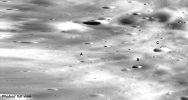
Phobos_from_Mgs-007.jpgPhobos, from MGS (Original NASA/MGS/MSSS Full Frame n. 1)64 visiteLett. A: grappolo di boulders a forma "colonnare" (si direbbe un gruppo di tre boulders allineati secondo un ordine dimensionale coerente ed un ulteriore rilievo, anch'esso di apparenza colonnare, posto nelle immediate vicinanze del primo gruppo).
Lett. B: rilievo anomalo, decisamente alto (a giudicare dall'ombra che proietta), posto sul versante interno di un cratere di modeste diomensioni, a circa mezza altezza della murata.
Lett. C: gruppo di rilievi anomali (si direbbe 3 o 4) - concettualmente molto simili al grappolo di boulders evidenziato sub lett. A - posti sul ciglio di un cratere di medie dimensioni.MareKromium
(6 voti)
|
|

North_Polar_Features-Unconformities-01.jpgNorth Polar "Unconformities" (Original NASA/MGS/MSSS b/w Frame)64 visiteCaption NASA originale:"This MGS-MOC image shows Layers exposed in the North Polar Region of Mars. The North Polar Cap is underlain by a thick sequence of Layered Material. The Layers are most commonly exposed on the slopes of troughs that are believed to have formed by Wind Erosion. The Layers give a banded appearance. In this example, some of the Layers are cut off (truncated) by other Layers. This truncation is a classic, textbook example of an Erosional Unconformity, a term commonly used by geologists. The Unconformity occurs when deposition of new layered material stops for a while and erosion occurs. Then, new layers form on top of the eroded surface and the older layers, at some point in time when the erosion stops and deposition of layered material resumes".
Location near: 78,6° North Lat. and 342,0° West Long.
Image width: ~3 Km (~1,9 mi)
Illumination from: upper right
Season: Northern Spring
(6 voti)
|
|

Aeolian_Features-Yardangs-Terra_Sabaea-MGS-02.jpgYardangs in Terra Sabaea (3 - Original NASA/MGS/MSSS b/w Frame)67 visiteLocation near: 1,4° North Lat. and 333,9° West Long.
Image width: ~3 Km (~1,9 mi)
Illumination from: upper left
Season: Northern Spring
(6 voti)
|
|

Aeolian_Features-Yardangs-Terra_Sabaea-MGS-01.jpgYardangs in Terra Sabaea (2 - Original NASA/MGS/MSSS b/w Frame)70 visiteLocation near: 1,4° North Lat. and 333,9° West Long.
Image width: ~3 Km (~1,9 mi)
Illumination from: upper left
Season: Northern Spring
(6 voti)
|
|

Aeolian_Features-Yardangs-Terra_Sabaea-MGS-00.jpgYardangs in Terra Sabaea (1 - Original NASA/MGS/MSSS b/w Frame)67 visiteCaption NASA originale:"This MGS-MOC image shows the contact between a group of Yardangs, tapered Ridges formed by the removal of relatively easily-eroded material (e.g.: Sedimentary Rock) and a concentration of dark-toned windblown Sand on the Floor of an Unnamed Crater in the Terra Sabaea Region of Mars".
Location near: 1,4° North Lat. and 333,9° West Long.
Image width: ~3 Km (~1,9 mi)
Illumination from: upper left
Season: Northern Spring
(6 voti)
|
|

North_Polar_Features-Unconformity-MGS-01.jpgNorth Polar "Unconformity" (Original NASA/MGS/MSSS b/w Frame)64 visiteCaption NASA originale:"This MGS-MOC image shows layered material exposed on a slope in the North Polar Region.
An "unconformity" is visible in the middle/lower left of the image, where layers are abruptly truncated. Unconformities are indicators of drastic change in the Region — the lower layers were deposited first, then eroded, then the upper layers were deposited".
Location near: 81,1° North Lat. and 75,2° West Long.
Image width: ~3 Km (~1,9 mi)
Illumination from: lower left
Season: Northern Spring
(6 voti)
|
|

North_Polar_Features-Unconformities-00.jpgNorth Polar "Unconformity" (Original NASA/MGS/MSSS b/w Frame)72 visiteCaption NASA originale:"This MGS-MOC image shows an Unconformity in an exposure of North Polar Layered Material, at which older Layers were cut-off and eroded before a new suite of Layers was deposited above them.
The Terrain in the entire scene was covered by a thin layer of CO2 Frost at the time this picture was acquired in June 2006".
Location near: 86,1° North Lat. and 208,5° West Long.
Image width: ~4 Km (~2,5 mi)
Illumination from: lower left
Season: Northern Spring
(6 voti)
|
|

South_Polar_Features-Fans-PIA08658.jpgSouth Polar Fans (Original NASA/MGS/MSSS b/w Frames)66 visiteCaption NASA originale:"Dark spots (left) and 'Fans' appear to scribble dusty hieroglyphics on top of the Martian South Polar Cap in two High-Resolution MGS-MOC images taken in Southern Spring. Each image is about 3-Km wide".
(6 voti)
|
|
| 512 immagini su 43 pagina(e) |
 |
|
|
|
|
19 | |
|
|
|
|








