| Piú viste - A Tribute To Mars Global Surveyor |

South_Polar_Regions-Hills_and_Knobs.jpgHills, Knobs and Buried Craters in the South Polar Region (Original NASA/MGS/MSSS b/w Frame)69 visiteOriginal caption:"This MGS-MOC image shows a Summer scene from the South Polar Region of Mars. The circular feature in the North-East (upper right) corner of the image is an old meteor impact crater that has been partially filled and buried. The cone-shaped hill that occurs within the crater on its East (right) side is a remnant of material that once covered and completely buried the crater. Perhaps beneath the surfaces in the rest of the image there are other craters that have been filled and buried such that we cannot know, from an image, that they ever existed. The theme of filled, buried, and exhumed craters is one that repeats itself —over and over again — all over Mars".
Location near: 80,3° South Lat. and 286,1° West Long.
Image width: ~3 Km (~1,9 mi)
Illumination from: upper left
Season: Southern Summer
|
|
Craters-Unnamed_Crater_in_Terra_Sabaea-01.jpgBuried Crater in Terra Sabaea (Original NASA/MGS/MSSS b/w Frame)69 visiteCaption originale:"This MGS-MOC image shows a 1,5 mt (~5 feet) per pixel view of a subdued circular feature which is probably an ancient Impact Crater that was buried and only partially exhumed (a common occurrence on Mars)".
Location near: 21,9° South Lat. and 338,6° West Long.
Image width: ~3 Km (~1,9 mi)
Illumination from: upper left
Season: Southern Summer
|
|

Clouds-South_Polar_Regions-PIA02694-1.jpgThick Clouds over the South Pole (Original NASA/MGS/MSSS b/w Frame)69 visiteThese clouds occurred near the South Polar Cap at the end of Southern Summer.
Image information: VIS instrument;
Latitude: - 80,3° North;
Longitude: 84,9° East;
Resolution: 17 meter/pixel.
|
|

Dunes-Noachis_Terra-00.jpgDark Dunes in Noachis Terra (Original NASA/JPL/MSSS b/w Frame)69 visiteCaption originale:"This MGS-MOC image shows Dark Sand Dunes and relatively small, light-toned, windblown Ripples on the Floor of an Unnamed Crater located in central Noachis Terra".
Location near: 50,0° South Lat. and 353,7° West Long.
Image width: ~3 Km (~1,9 mi)
Illumination from: upper left
Season: Southern Autumn
|
|

Craters-Spallanzani_Crater-MGS-00.JPGLayered "Mesa" inside Spallanzani Crater (Original NASA/MGS/MSSS b/w Frame)69 visiteCaption NASA originale:"This MGS-MOC image shows a layered, light-toned Mesa among other Layered Materials exposed in a mound that covers much of the Floor of Spallanzani Crater".
Location near: 58,3° South Lat. and 273,9° West Long.
Image width: ~3 Km (~1,9 mi)
Illumination from: upper left
Season: Southern Summer
|
|

Craters-Unnamed_Crater_in_Terra_Tyrrhena-01.jpgUnnamed Crater and Dunes in Terra Tyrrhena (Original NASA/MGS/MSSS b/w Frame)69 visiteCaption originale:"This MGS-MOC image shows a portion of a Field of Dark Sand Dunes superposed on the light-toned Floor of an Unnamed Crater located in Eastern Tyrrhena Terra. The orientation of the Dunes — with the steep faces toward the South (right) — suggests that winds generally blew from North to South at the time the dunes were formed".
Location near: 14,6° South Lat and 262,3° West Long.
Image width: ~3 Km (~1,9 mi)
Illumination from: lower left
Season: Southern Summer
Nota: la caption originale, come spesso sta accadendo, esprimendosi sulla direzione dei venti che avrebbero scolpito le dune della Terra Tirrena è - scusateci - così stupida che meriterebbe la censura (faremmo solo un favore alla NASA). Tuttavia, dato che il servizio che noi cerchiamo di rendere vuole coprire anche alcuni lati "curiosi" (sic!) della Divulgazione Scientifica, abbiamo pensato di lasciare il commentino ufficiale integro, così che qualsiasi Lettore, leggendolo, possa rendersi conto di che cosa significa "parlare (rectius: scrivere) quando non si ha proprio nulla da dire (scrivere)".
|
|

Channels-Auqakuh_Vallis-MGS.JPGAuqakuh Vallis: "Old Riverbed" or "Windblown Ripples"? (Original NASA/MGS/MSSS b/w Frame)69 visiteCaption NASA originale:"This MGS-MOC image shows windblown ripples on the floor of Auqakuh Vallis.
The light-toned area, running diagonally across the scene from South-West to North-East, may be dust that has accumulated in the bottom of the valley and on top of the ripples".
Location near: 31,3° North; 299,3° West
Image width: ~3 Km (~1,9 mi)
Illumination from: lower left
Season: Northern Spring
|
|

North_Polar_Features-Polar_Cone-MGS-00.jpgNorth Polar "Cone" (Original NASA/MGS/MSSS b/w Frame)69 visiteCaption NASA originale:"This MGS-MOC image shows a cone-shaped hill, perhaps a remnant of a material that was once more laterally extensive across the area, on a textured plain in the Hyperboreus Labyrinthus Region in the North Polar Region of Mars.
The hill and its surroundings are covered with a blanket of solid CO2 which imparts a roughly homogeneous-tone to the scene.
Despite its shape, the feature is not a volcano; over the past 9 years, the MGS-MOC investigation has found no unambiguous evidence for volcanic landforms in the North Polar Region".
Location near: 79,5° North; 57,0° West
Image width: ~3 Km (~1,9 mi)
Illumination from: lower left
Season: Northern Spring
|
|

Controversial_Features-The_Bridges_of_Meroe_Patera-MGS-1.jpgThe "White Bridges" of Meroe Patera (Original NASA/MGS/MSSS CTX b/w Frame)69 visiteCaption NASA originale:"This MGS-MOC image shows terrain South-West of Meroe Patera in Syrtis Major Planum, Mars. Wind streaks formed in the "lee" (the downwind side) of impact craters are common throughout the scene, including the small impact crater near the center of the image with light-toned ejecta radiating outward from its rim.
Near the South (Dx) of the image, 3 light-toned slope streaks, created by dry mass movements of dust, extend down the sloping side walls of two overlapping impact craters".
Location near: 5,3° North; 295,4° West
Image width: ~3 Km (~1,9 mi)
Illumination from: lower left
Season: Northern Winter
|
|
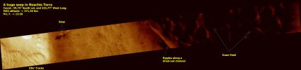
Noachis_Terra-M1501427-PCF-LXTT-00.jpgNoachis Panorama (CTX Frame - Enhanced and Darkened Natural Colors; credits for the additional process. and color.: Dr Paolo C. Fienga - Lunexit Team)69 visitenessun commento
|
|
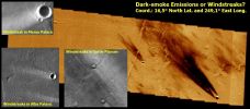
Aeolian_Features-Windstreaks-Comparison.jpgWindstreaks inside Becquerel Crater (CTX Frame: False Colors - insets: Original NASA/MGS/MSSS and NASA/JPL/ASU b/w Frames)69 visiteUn piccolo mosaico, tanto per evidenziare la notevole (sempre e solo a nostro avviso, naturalmente) diversità esistente fra alcuni Windstreaks.
Tanto per prevenire possibili malintesi, ribadiamo che il Windstreak, tecnicamente, è (o forse sarebbe meglio dire "dovrebbe essere") l'espressione visibile di un'area superficiale "protetta" da un rilievo la quale, di conseguenza ed a differenza delle aree ad essa latistanti, NON viene spazzata dal vento (diciamo che è "risparmiata").
Ma alcuni Windstreaks, a differenza di quanto detto qui di sopra, esprimono invece il risultato visibile di quanto il vento ha DIRETTAMENTE trasportato su una specifica area superficiale (il che vuol dire che essi non rappresentano un'area "coperta", bensì un'area "battuta").
Questa distinzione costituisce una mera "finezza/sottigliezza" interpretativa, forse? Secondo noi no. No perchè una cosa è guardare cosa accade ad un'area su cui il vento non arriva a battere direttamente (a causa della presenza di un ostacolo) ed un'altra osservare che cosa il vento ha trasportato su una certa superficie, battendo direttamente su di essa.
Osservate l'omogeneità iniziale del tre Windstreaks presenti nei frames in b/n (si tratta dunque di Windstreaks che evidentemente esprimono delle aree "protette") e la forma a "V" dei Windstreaks individuati nelle prossimità di Ascraeus (i quali, ora ed altrettanto evidentemente, esprimono aree "battute").
Le implicazioni derivanti da questa (sommaria, ma non insignificante) classificazione dei Windstreaks ci paiono talmente evidenti da non necessitare, in questa sede, di ulteriori spiegazioni.MareKromium
|
|

Inca-City-M0306902-00.jpgA true "South Polar Oddity": Inca City (2 - False Colors)69 visite"Inca City" is the informal name given by Mariner 9 Scientists in 1972 to a set of intersecting, rectilinear ridges that are located among the layered materials of the South Polar Region of Mars. Their origin has never been understood; most investigators thought they might be sand dunes, either modern dunes or, more likely, dunes that were buried, hardened, then exhumed. Others considered them to be dikes formed by injection of molten rock (magma) or soft sediment into subsurface cracks that subsequently hardened and then were exposed at the surface by wind erosion.
|
|
| 512 immagini su 43 pagina(e) |
 |
|
|
|
|
33 | |
|
|
|
|








