| Piú viste - A Tribute To Mars Global Surveyor |

Phobos-00-HR-117-051004-6xSRC-6-col-01-Phobos.jpgDifferent views of Phobos (Original NASA/MGS/MSSS b/w Frames)96 visiteUna serie di immagini ottenute dalla Sonda ESA "Mars Express" le quali ci fanno gradualmente "avvicinare" a Phobos ed alla sua affascinante (ed in parte assolutamente inspiegabile) superficie. Molto ben visibile, in tutti i sub-frames, la più grande e conosciuta caratteristica superficiale di Phobos: lo Stickney Crater.
|
|

Craters-Airy_Crater-The_Prime_Meridian-1.JPGMars' Prime Meridian, such as: Longitude "0" (2 - Original NASA/MGS/MSSS CTX b/w Frame)96 visiteBeer and Mädler used a small circular feature, which they designated "a" as a reference point to determine the rotation period of Mars. The Italian astronomer G. V. Schiaparelli, in his 1877 map of Mars, used this feature as the 0 point of Longitude. It was subsequently named Sinus Meridiani ("Middle Bay") by Camille Flammarion.
When Mariner 9 mapped the Planet at about 1 Km (0,62 mile) resolution in 1972, an extensive control net of locations was computed by Merton Davies of the RAND Corporation. Davies designated a 0,5-Km-wide crater, subsequently named Airy-0 (within the large crater Airy in Sinus Meridiani) as the Longitude 0 point.
Airy-0 was imaged once by Mariner 9 and once by the Viking 1 orbiter in 1978, and these 2 images were the basis of the Martian Longitude System for the rest of the 20th Century. The MGS has attempted to take a picture of Airy-0 on every close overflight since the beginning of the mapping of Mars.
|
|

Craters-Unnamed_Crater_in_Noachis_Terra-PIA07202_modest.jpgUnnamed Crater in Noachis Terra (Original NASA/MGS/MSSS b/w Frame)95 visiteCaption NASA originale: "This Mars Global Surveyor (MGS) Mars Orbiter Camera (MOC) image shows an impact crater, a little over 2 Km (> 1,2 mi) in diameter, located in Noachis Terra near 50.4°S, 14.3°W. The crater's bouldery ejecta blanket has protected underlying material from being eroded away by wind, leaving the ejecta up on a low pedestal. This picture covers an area about 3 km (1.9 mi) across, and is illuminated by sunlight from the upper left".
|
|

Aeolian_Features-Dust_Storms-Mars___Earth_Comparison.jpgDust Storms on Mars and Earth95 visiteUn'interessante confronto fra una tempesta di sabbia Marziana (come vista dalla Sonda Mars Global Surveyor) ed una tempesta di sabbia che, sollevatasi con ogni probabilità dalla porzione più occidentale del deserto del Sahara, si sta ora spostando al largo dell'Oceano Atlantico.
Indubbiamente un'immagine suggestiva che evidenzia le diversità più che le similitudini esistenti fra la Terra e Marte. Inoltre, sempre secondo noi, la coloritura che è stata data alla "nube sabbiosa" terrestre è - anche in questo caso - davvero discutibile.
Chissà, forse alla NASA l'attribuzione dei colori alle immagini costituisce un problema davvero insuperabile...
|
|
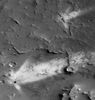
Aeolian_Features-Windstreaks-Becquerel_Crater-M0702802-00.jpgWindstreaks inside Becquerel Crater (Original NASA/MGS/MSSS b/w Frame)95 visitenessun commento
|
|
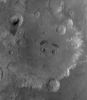
Craters-Tikhonravov_Crater-PIA07196.jpgThe "Eyes" and "Eyebrows" of Tikhonravov Crater (Original NASA/MGS/MSSS b/w Frame)94 visiteCaption NASA originale:"This red wide angle MGS-MOC image shows Tikhonravov Crater in Central Arabia Terra. The Crater is about 386 Km (approx. 240 miles) in diameter and presents two Unnamed Impact Craters at its center that have dark patches of Sand in them, giving the impression of pupils in two eyes. Each of these two Unnamed Craters lies a dark-toned patch of Surface Material, providing the impression of eyebrows.
M. K. Tikhonravov was a leading Russian rocket engineer in the 20th Century. The crater named for him, despite its large size, is still partly buried, on its West Side, beneath the heavily Cratered Terrain of Arabia Terra. The center of Tikhonravov is near 13,5° North Lat. and 324,2° West Long. Sunlight illuminates the scene from the upper left".
|
|

Volcanic_Features-Collapse_Pits-Pavonis_Mons_Area.jpgPit Chain on the Eastern Flank of Pavonis Mons (Original NASA/MGS/MSSS b/w Frame)94 visiteCaption NASA originale:"Pavonis Mons is the middle of the 3 large Tharsis Montes Volcanoes in the Martian Western Hemisphere.
Located on the Equator at about 113° West Longitude, Pavonis Mons stands as much as 7 Km above the surrounding Plain. The MGS-MOC recently spied the above Chain of Elliptical Pits on the lower East Flank of Pavonis Mons. The picture covers an area approx. 3 Km wide by 3,4 Km in length. The Pits are aligned down the center of a 485 meters-(approx. 530 yards)-wide, shallow Trough.
The straight Trough and the Pits were both formed by collapse associated with faulting. The Scarp on each side of the Trough is a "Fault Line" - Troughs of this type are known to geologists as "Graben". Such features are typically formed when the ground is being moved apart by tectonic forces, or when the ground is uplifted by molten rock injected into the near sub-surface from deeper underground. Both processes may be contributing to the features seen on Pavonis Mons. The Pits follow the trend of these Faults, and indicate the locus of collapse".
|
|

South_Polar_Features-Defrosting_Dunes-2005_06-00.jpgDefrosting Dunes (Original NASA/MGS/MSSS b/w Frame)94 visiteCaption NASA originale:"This MGS-MOC image shows dark spots formed in carbon dioxide frost that covers the surfaces of patches of sand in the South Polar Region. As spring arrived this year in the Martian Southern Hemisphere, so began the annual defrosting process.
The fact that sand dunes begin to defrost earlier than other surfaces and that the defrosting process involves the formation of spots like these, has been known since the earliest days of the MGS mission".
Location near: 66,8°S; 15,7°W
Image width: ~3 Km (~1,9 mi)
Illumination from: upper left
Season: Southern Spring
|
|

Acidalia_Region-M0300102-01.jpgBizarre-looking Troughs in Acidalia Region (2 - Original NASA/MGS/MSSS b/w - EDM n.1)94 visitenessun commento
|
|

Craters-Korolev_Crater-PIA06896-PCF-LXTT.jpgWave Clouds off Korolev Crater (Absolute Natural Colors; credits for the additional process. and color.: Dr Paolo C. Fienga - Lunexit Team)94 visiteCaption NASA:"This red wide angle Mars Global Surveyor (MGS) Mars Orbiter Camera (MOC) image shows a wavy Cloud Pattern formed in the lee of Korolev Crater, which is located near 72,8° North and 195,7° West (Vastitas Borealis Region). Korolev Crater is about 85 km (approx. 53 mi) in diameter and named for Sergei P. Korolev, a pioneering Russian rocket designer and engineer who died in the mid-1960s. The image, acquired in late Northern Summer, is illuminated by sunlight from the lower left".MareKromium
|
|

Channels-Uzboi_Vallis-B-M1100709.jpgChannels's Network in Uzboi Vallis (2 - EDM)93 visiteForse ci sbagliamo, ma il ragionamento che sta alle spalle dell'enfasi posta sulle (onestamente meno probabili, in termini di vita secondo lo schema terrestre) analogie Terra/Titano e sulla costante indifferenza rispetto alle (decisamente più plausibili) analogie Terra/Marte, dovrebbe trovare la sua ragione in questo: è molto più semplice (ed anche molto più sicuro) far "girare a vuoto" la mente degli Osservatori suggerendo loro delle ipotesi affascinanti, ma improbabili, piuttosto che rinforzare le supposizioni e le aspettative già esistenti ponendo accenti sempre più marcati sulle profonde (e talora inequivocabili) similitudini esistenti fra il nostro Mondo e Marte.
Non dimentichiamo, infatti che il Pianeta Rosso non è solo più vicino e familiare, ma è anche - decisamente - più accessibile ad una verifica diretta: in fondo, sono solo cinque mesi e mezzo di viaggio...
|
|

South_Polar_Features_-_The_Lake-A1-M0901354-01.jpgSouth Polar Lake? (EDM)93 visiteNon crediamo di dire una sciocchezza (di dimensioni planetarie...) allorché supponiamo che questo restringimento sia da... attribuire ad un sostanziale 'riscaldamento' dell'atmosfera del Pianeta. E se la temperatura dell'atmosfera di Marte riuscisse effettivamente ad alzarsi, in media, anche di soli 10/12 gradi, la possibilità che, almeno nei mesi estivi, si riesca a vedere acqua allo stato liquido sulla superficie del Pianeta non sarebbe più un'eventualità del tutto remota ed inaccettabile.
Certo: si potrebbe obiettare che l'atmosfera di Marte è comunque troppo sottile per consentire all'acqua di 'restare sulla superficie', ma Voi provate a pensare a questo "dettaglio": coloro che ci parlano delle caratteristiche dell'atmosfera di Marte sono gli stessi personaggi che nascondono le reali scoperte fatte sulla Luna e che hanno vietato a TUTTI gli Astronauti del programma Apollo di aprire bocca e parlare di ciò che hanno visto.
|
|
| 512 immagini su 43 pagina(e) |
 |
|
|
|
|
21 | |
|
|
|
|








