|
|
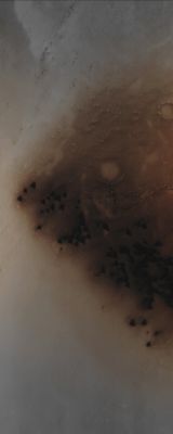
Equatorial Dunefield (Absolute Natural Colors; credits for the additional process. and color. Dr Paolo C. Fienga/Lunar Explorer Italia/Italian Planetary Foundation)
|
Mars Local Time: 14:08 (Early Afternoon)
Coord. (centered): 1,068° North Lat. and 30,111° East Long.
Spacecraft altitude: 268,9 Km (such as about 166,986 miles)
Original image scale range: 53,8 cm/pixel (with 2 x 2 binning) so objects ~ 1 mt and 61 cm across are resolved
Map projected scale: 50 cm/pixel
Map projection: EQUIRECTANGULAR
Emission Angle: 0,0°
Phase Angle: 34,9°
Solar Incidence Angle: 35° (meaning that the Sun was about 55° above the Local Horizon at the time the picture was taken)
Solar Longitude: 328,5° (Northern Winter - Southern Summer)
Credits: NASA/JPL/University of Arizona
Additional process. and coloring: Lunar Explorer Italia
This picture (which is a NASA - Original Mars Reconnaissance Orbiter NON-Map Projected CTX b/w frame identified by the serial n. ESP_032097_1810) has been additionally processed and then colorized in Absolute Natural Colors (such as the colors that a human eye would actually perceive if someone were onboard the NASA - Mars Reconnaissance Orbiter and then looked down, towards the Surface of Mars), by using an original technique created - and, in time, dramatically improved - by the Lunar Explorer Italia Team.
|
|