| Piú votate - Mars Spirit Anomalies and Maps |
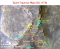
ZP-F-MERA_A1173_1_br2.jpgWhere is Spirit? (4)107 visitenessun commentoMareKromium
(4 voti)
|
|
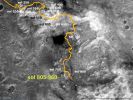
ZP-D-MERA_A960_2.jpgWhere's Spirit? (2)144 visitenessun commento
(4 voti)
|
|
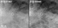
ZP-B-R131467_S1200095loc.JPGMOC2-1331d: A "before" image from January 2004 (left) and the Rover image from November 2005 (right) - Where's "MER Spirit"? (3)195 visiteOriginal caption:"This picture (MOC2-1331d) shows the location of the Rover in the 2 November 2005 image (S12-00095) inside a white circle. This is compared with the view taken on 10 January 2004 in R13-01467. Back on 10 January 2004, very few ever dreamed that the Rover would ever reach the Columbia Hills.
A Mars year later, the Rover was at the Summit and then headed down the other side of the Hills".
Location near: 14,8° S; 184,6° W
MOC2-1331a Image width: ~3 Km (~1,9 mi);
MOC2-1331d 50 mt scale bar = 164 ft
Illumination from: left
Season: Southern Summer in both R13-01467 and S12-00095
(4 voti)
|
|
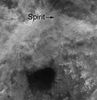
ZP-A-S1200095MERA100.JPGMOC2-1331c: Spirit Location, 2 November 2005 - Where's "MER Spirit"? (2)177 visiteOriginal caption:"This picture (MOC2-1331c) shows the Spirit Rover at its 2 November 2005 (Sol 652) location.
Dr. Timothy J. Parker of the MER Team at the NASA/Caltech Jet Propulsion Laboratory confirmed the location of the Rover in the MOC image.
The Region South (toward the bottom) of these images shows the area where the Rover is currently headed.
The large dark patch and other similar dark patches in these images are accumulations of windblown sand and granules".
(4 voti)
|
|
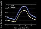
VH-temperature6-A10R1_br.jpgIs Mars very cold?!? It depends on the altitude...202 visiteCaption NASA originale:"This graph shows the predicted daily change in the atmospheric temperature 1 (one) meter above the surface of Mars at Gusev Crater. The blue curve denotes predicted values for Sol 1 (the first day of Spirit's mission) and the yellow for Sol 100 (100 days into the mission).
The light blue symbols represent temperatures for a total atmospheric dust abundance of 0,7 visible optical depth units, and the darker blue symbols for a total atmospheric dust abundance of 1,0 visible optical depth units.
Scientists use this data to ensure that Spirit stays within the right temperature range".
Nota: i valori di questo grafico, a nostro parere - e dopo aver confrontato tutti i dati (NASA ed ESA) disponibili - fanno apparire Marte decisamente più freddo di quanto non sia.
Almeno in teoria...
(4 voti)
|
|
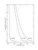
VG-temperature_profile-A12R1_br2.jpgIs Mars very cold?!? It depends on the altitude...183 visiteThis graph shows the temperature above the the surface of Mars at three different points in time: Sol 5, late afternoon; Sol 6, mid-morning; and Sol 7, early afternoon (Sol 5 occurred on the night of January 7/8, 2004). These temperature profiles were derived from data taken by the MTES onboard the Mars Exploration Rover Spirit.
By measuring the brightness of the carbon dioxide gas that makes up the Martian Atmosphere, scientists can deduce the surface temperature above Mars between 20 mt (65 feet) and 2 Km (approx. 1,2 miles).
The observations show large changes in atmospheric temperature both as a function of time of day and as a function of height near the surface.
In altre parole: la NASA dice che se tocchiamo il suolo di Marte, in pieno giorno, riceveremo una sensazione di calore (p.e.: intorno alle ore 13 MLT, durante l'Estate Marziana, la temperatura al suolo - e sempre according to NASA - potrebbe oscillare tra i 15 ed i 20°C mentre secondo noi, invece, potremmo tranquillamente stare sopra i 25/28°).
Tuttavia, basterà 'salire' di 2 metri (e cioè alzarsi, o fare un saltino) per ritrovarsi nel gelo polare! Possibile?
Ai Posteri (che cammineranno su Marte) l'ardua Sentenza!...
(4 voti)
|
|
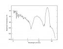
VF-spectrum-A12R1_br2~0.jpgWhat's inside the Sky of Mars? Carbon dioxide, mostly...212 visiteA view of the sky as observed by the Mini-Thermal Emission Spectrometer onboard the Mars Exploration Rover Spirit. This instrument detects the different wavelengths of infrared light emitted by an object, in this case the sky, producing a graph (called a spectrum) that reveals the presence of specific chemicals. This spectrum, taken on Sol 7 in the early afternoon (night of January 9/10, 2004), contains the signatures of carbon dioxide (15 microns), atmospheric dust (9 microns) and water vapor (6 microns). Scientists also expect to see water ice clouds in the Martian Atmosphere, but did not observe them at the time of this observation. The thermal brightness of carbon dioxide allows the atmospheric temperature as a function of height to be determined.
Carbon dioxide makes up 95% of the Martian Atmosphere".
(4 voti)
|
|

VF-nav4-A11R1_br.jpgWhere's Spirit? (3)216 visiteE chiudiamo la 'Ricerca di Spirit" con questa Mappa che è stata ottenuta grazie ai dati (telemetrici e fotografici - si vedano, per questi ultimi, le 3 immagini proposte nella Sezione "Walking on Mars") ottenuti dal Descent Image Motion Estimation System - o DIMES(C) - il quale, come ormai saprete, è collocato sulla 'pancia' del Lander.
(4 voti)
|
|
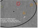
VD-nav2-A11R1.jpgWhere's Spirit? (2)220 visiteQuesto secondo frame rappresenta solo un detail mgnf della precedente Mappa radiometrica. E' importante, a nostro avviso, fare un piccolo sforzo e familiarizzare con questo tipo di mappe e con la tecnologia che esiste alle loro spalle: un giorno (e speriamo non fra un secolo!), il viaggio che porterà degli uomini su Marte si concluderà comunque in questo modo. Avremo, cioè, un'area ellittica entro la quale verrà collocato il punto stimato di landing e poi, sia usando i dati video trasmessi dalla superficie, sia incrociando le informazioni relative ai segnali (eco) emessi dal Lander durante la discesa - telemetrie - verrà determinato l'esatto landing site.
Riteniamo altresì molto probabile il ricorso a strumenti ottici - oggi in corso di sviluppo - i quali consentiranno delle verifiche visuali ed in tempo reale sia da parte della Mothership che resterà in orbita (un equivalente del CSM per i LM Apollo), sia da parte del network satellitare di cui allora disporremo intorno al Pianeta Rosso.
(4 voti)
|
|
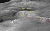
ZO-X-PIA07851_fig1.jpgColumbia Hills' Perspective View (from MGS)218 visiteCaption NASA originale:"This perspective view of a 3D terrain model shows the shape of the "Columbia Hills" landscape where NASA's Mars Exploration Rover Spirit has been working since mid-2004.
North is toward the lower left.
Husband Hill is at the center, with the Inner Basin behind it. This view is from images taken by the Mars Orbiter Camera on NASA's Mars Global Surveyor and processed into a 3D terrain model by the U.S. Geological Survey - USGS".
(4 voti)
|
|
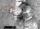
ZO-V-PIA07850_fig1.jpgThe path of Spirit up to Sol 450215 visiteCaption NASA originale:"This orbital view shows the path of Spirit's trek through the "Columbia Hills," beginning on the "West Spur" on Sol 156 (June 11, 2004) and continuing up the flanks of "Husband Hill." The dashed line indicates the perimeter of the Columbia Hills, which consist of older rocks of different composition than those of the surrounding plain. The path of Spirit's trek is overlain on imagery from the Mars Orbiter Camera on NASA's Mars Global Surveyor. The 500-meter scale bar is equivalent to 1.640 feet".
(4 voti)
|
|
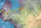
ZN-SOL343-Spirit_travmap_GeoDEM_2-A350R1.jpgThe path of Spirit up to Sol 343233 visiteCaption NASA originale:"As NASA's Mars Exploration Rover Spirit continues to explore the "Columbia Hills" within Gusaev Crater, scientists are planning to take a closer look for layered rocks in a steep valley straight ahead before directing the rover to turn south toward the summit of "Husband Hill." Two of the geologic formations the six-wheeled robotic geologist has discovered during 2004 are shown here. One is labeled "Columbia Hills material," representing bedrock of the higher slopes and peaks, and one is labeled "transition zone material," representing rocks that are gradational in character and composition between the hills to the east and the plains to the west. The map also shows Spirit's line of travel through the rover's 344th Sol (Dec. 21, 2004), beginning on the left edge at about the 182nd Sol (July 7, 2004)".
(4 voti)
|
|
| 274 immagini su 23 pagina(e) |
 |
|
|
|
|
12 | |
|
|
|
|








