| Piú votate - Mars in JPEG2000 |

PSP_008548_2205_RED_abrowse-01.jpgDo You Remember "GENESIS"?!? - Mounds in Acidalia Planitia (natural colors; credits: Dr M. Faccin & Lunexit)258 visitenessun commentoMareKromium
(7 voti)
|
|

PSP_006755_2030_RED_abrowse-1.jpgUnusual Surface Features in Mawrth Vallis Channel: the "Tepe" (EDM - credits for the additional process.: Dr Gianluigi Barca - Lunexit Team)80 visitenessun commentoMareKromium
(7 voti)
|
|
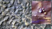
PSP_007820_1505_RED_abrowse-44.JPGThe "Sun-Door" (the measures - credits: Dr M. Faccin)125 visitenessun commentoMareKromium
(7 voti)
|
|
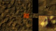
PSP_007820_1505_RED_abrowse-42.jpgThe "Sun-Door" (extra-detail mgnf n. 1 - credits: Dr M. Faccin)159 visiteAi piedi del boulder "Maggiore", una sorgente di luce. O meglio: un ulteriore rilievo ad albedo di gran lunga più elevata rispetto all'albedo delle altre rocce che formano il gruppo.
Il boulder "Maggiore", poi, oltre ad essere caratterizzato da una forma rettangolare e da un colorito azzurro,non pare giacere sul suo lato lungo bensì su quello corto (tipo il Monolito di "2001", tanto per capirci); dietro di esso, una rosa di tre macigni, il primo dei quali (quello più in basso nel frame) ostenta una evidente base quadrata.
Geometria, Simmetria e Contestualizzazione: la "Sacra Trinità" dell'Anomaly Hunter, in questo caso specifico, è soddisfatta.
Il rilievo, come si conviene, à stato battezzato (diremmo per evidenti motivi) "La Porta del Sole". Noi possiamo solo invitarVi a guardare, a riflettere ed a commentare...Se volete.MareKromium
(7 voti)
|
|

Dunes-PIA14880.gifDegrading North Polar Barchan-type Dune (a GIF-Movie by NASA/JPL-Caltech/Univ. of Ariz./JHUAPL)213 visitenessun commentoMareKromium
(6 voti)
|
|

Dunes-PIA14880-PCF-LXTT-1.jpgDegrading North Polar Barchan-type Dune (Absolute Natural Colors; credits for the additional process. and color.: Dr Paolo C. Fienga - Lunexit Team)220 visiteThis Dune, located in the North Polar Region of Mars, showed significant changes between two images taken on June 25th, 2008 and May 21st, 2010 and revealed Landslides and Sand advancing at the Dune-Front (upper left); changes in the position of the rest of the Dune Boundary relative to the fixed, underlying Terrain and changes in the position of the Ripples located on the Dune Surface.
MareKromium
(6 voti)
|
|

Dunes-PIA14876-PCF-LXTT.jpgRippled Patch of Sand in Becquerel Crater (Enhanced Absolute Natural Colors; credits for the additional process. and color.: Dr Paolo C. Fienga - Lunexit Team)201 visiteA Rippled Patch of Sand in Becquerel Crater on Mars moved about 2 meters (such as about 2 yards) between November 24th, 2006 and September 5th, 2010. Becquerel Crater is located just north of the equator in the Arabia Terra region.
MareKromium
(6 voti)
|
|

Dunes-PIA14879-PCF-LXTT.jpgMoving Rippled Dune-Front in Hershel Crater (Enhanced Absolute Natural Colors; credits for the additional process. and color.: Dr Paolo C. Fienga - Lunexit Team)207 visiteA Rippled Dune-Front in Herschel Crater on Mars moved an average of about 1 meter (such as about o1 yard) between March 3rd, 2007 and December 1st, 2010. Herschel Crater is located just South of the Equator, in the Cratered Highlands.
This is one of several sites where the MRO has observed shifting Sand Dunes and Ripples. Previously, scientists thought sand on Mars was mostly immobile. It took the mission's High Resolution Imaging Science Experiment (HiRISE) to take sharp enough images to finally see the movement. While Dust is easily blown around the Red Planet, its thin Atmosphere means that strong Winds are required to move Grains of Sand.MareKromium
(6 voti)
|
|

Dunes-PIA14878-PCF-LXTT.jpgMoving Rippled Dune-Front in Hershel Crater (Enhanced Absolute Natural Colors; credits for the additional process. and color.: Dr Paolo C. Fienga - Lunexit Team)205 visiteA Rippled Dune-Front in Herschel Crater on Mars moved about 2 meters (such as about 2 yards) between March 3rd, 2007 and December 1st, 2010. Herschel Crater is located just South of the Equator in the Cratered Highlands.
This is one of several sites where the orbiter has observed shifting Sand Dunes and Ripples. Previously, scientists thought sand on Mars was mostly immobile. It took the mission's High Resolution Imaging Science Experiment (HiRISE) to take sharp enough images to finally see the movement. While Dust is easily blown around the Red Planet, its thin Atmosphere means that strong Winds are required to move Grains of Sand.MareKromium
(6 voti)
|
|
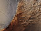
Chrise_Planitia-PIA14462-PCF-LXTT.jpgFeatures of Chrise Planitia (Absolute Natural Colors; credits for the additional process. and color: Dr Paolo C. Fienga - Lunexit Team)196 visiteThe suggested area in this observation is characterized by a group of Cones, such as "shield-like" features, and round Mounds. They are a few hundred meters to kilometers in diameter, but their heights are still unknown.MareKromium
(6 voti)
|
|

Crack_of_Unknown_Origin-ESP_022298_1555-GB-PCF-LXTT-02.jpgPossible Evidence of relatively recent Seismic Activity on Mars (credits for the Research and additional process.: Drr Gianluigi Barca and Paolo C. Fienga - Lunexit Team)252 visitenessun commentoMareKromium
(6 voti)
|
|

PSP_005370_1845_RED_abrowse-04.jpgExtremely unusually-looking Surface Feature in Sinus Meridiani (EDM n. 3 - Absolute Natural Colors; credits for the additional process. and color.: Drr Gianluigi Barca and Paolo C. Fienga - Lunexit Team)143 visitenessun commentoMareKromium
(6 voti)
|
|
| 199 immagini su 17 pagina(e) |
 |
|
|
|
6 | |
|
|
|
|
|








