| |

| Piú votate - Mars in JPEG2000 |

ESP_014342_0930-04.jpgSouth Polar Residual Cap Intraseasonal Change Monitoring (EDM n.4 - Natural Colors; credits: Lunexit)70 visitenessun commentoMareKromium
(9 voti)
|
|

PSP_009342_1725_RED_abrowse-1.jpgAnother "Martian Monolith"? (bird's eye view - credits: Dr M. Faccin)130 visiteSu suggerimento della nostra Amica Lettrice Elisabetta Bonora, abbiamo recuperato le immagini di un nuovo - possibile - "Enigma Marziano" (o, se vogliamo essere più tecnici, di una evidente Singolarità - possibile Anomalìa - di Superficie) e quindi, dopo aver ottenuto le migliori e le più dettagliate magnificazioni possibili (migliori, come ovvio, in rapporto ai nostri mezzi ed alle nostre capacità) del dettaglio, riteniamo che sia possibile ESCLUDERE la matrice "artificiale" del rilievo controverso.
Una premessa.
L'istinto dell'Osservatore (di QUALSIASI Osservatore!), come tutti ormai sanno perfettamente, costituisce una "guida", più o meno (in)conscia, verso quella interpretazione della realtà che più "soddisfa" e meglio "risponde", in fondo, alla Cultura, alla Sensibilità e, ovviamente, anche all'Immaginazione dell'Interprete.
Non è un caso, infatti ed a nostro modo di vedere, che una ricorrente (e possibile) Anomalìa Spaziale, alla fine, vada ad identificarsi in rilievi colonnari, pseudo colonnari e/o comunque simili ai terrestri Menhir, o Dolmen, o Monoliti, appunto.
Abbiamo Monoliti su Marte, sulla Luna (le "Cuspidi di Blair"), su Phobos, su Giapeto, forse anche su Encelado e chissà dove ancora ne troveremo.
Ma perchè sempre dei Monoliti? Forse perchè sono strutture rappresentative di un "qualcosa" di importante nell'Immaginario Collettivo Terrestre? O forse perchè siamo rimasti tutti un pò colpiti dall'immortale Monolito del film "2001 - A Space Odyssey"?
O forse perchè il Monolito, con la sua geometria essenziale ma imponente, costituisce - ad occhi e per occhi umani - un'adeguata rappresentazione di qualcosa di trascendente, di concettualmente elevato, forse addirittura di mistico, sino al punto di apparire come un Elemento Prossimo e/o Tendente a Dio e quindi - ed ovviamente a questo punto - un qualcosa di "artificiale"?
Andiamo a vedere bene l'immagine e, soprattutto, caliamo la possibile Anomalìa nel suo contesto.
Questo Metodo/Processo (la Contestualizzazione, appunto), sebbene possa apparire "dissacrante" - e forse può anche esserlo, in un certo senso - dobbiamo SEMPRE adottarlo poichè esso - a nostro parere - è l'UNICO METODO per non lasciarsi ingannare da fattezze le quali, in fondo, proprio perchè "lontane e suggestive", rischiano di confondere gli occhi e la mente di chi le osserva e le studia.
Andiamo quindi a guardare (ed a "vedere") meglio il tutto, calando il panorama nelle sue fattezze reali ed il nostro "Monolito" nel suo ambiente naturale...MareKromium
(9 voti)
|
|

ESP_012252_1245-00.jpgOutcrop in Southern Noachis (ctx frame - Natural Colors; credits: Dr M. Faccin)69 visiteCoord.: 55,1° South Lat. and 26,8° East Long.
Spacecraft altitude: about 251 Km
M.L.T.: 15:52 (middle afternoon)
S.I.A.: 58° (Sun about 32° high on the L.H.)MareKromium
(9 voti)
|
|

ESP_011610_1825-01.jpgFresh Triplet! (edm n. 2 - Natural Colors; credits: Dr M. Faccin)77 visitenessun commentoMareKromium
(9 voti)
|
|

PSP_006737_1265-Square04.jpgUnbelievable: a TRUE Martian Monolith! (edm n. 3 - credits: Dr M. Faccin)355 visiteOltre questo livello di ingrandimento - senza poi distruggere la ancora eccellente qualità del frame - non si può andare. Ma quanto ci mostra questa straordinaria iper-magnificazione (realizzata dal nostro eccezionale Dr Faccin) è più che sufficiente per formulare delle ipotesi credibili.
Una su tutte: l'oggetto anomalo è effettivamente una sorta di parallelepipedo (circa 1,8 x 2,4 mt), a pianta quadrata, apparentemente abbastanza liscio e regolare e dall'albedo particolarmente alta (nettamente più alta di quella del resto del paesaggio).MareKromium
(9 voti)
|
|

Cryptic_Terrain_on_Mars_(PSP_003179_0945)-1.jpgThese ARE NOT Trees! (Natural Colors; credits: Dr G. Barca & Lunar Explorer Italia)82 visiteUn altro "Mito" Marziano crolla miseramente grazie alle straordinarie ottiche della Sonda Mars Reconnaissance ed al formato JP2. I "Pioppi Marziani" - o, comunque, quei rilievi che svariati Esperti di Anomalìe Spaziali (da Hoagland al Dr Skipper) ritenevano essere delle INDISCUTIBILI EVIDENZE (!) di vegetazione locale - si rivelano per quel che sono: striature scure del suolo, di fatto assai simili ai Wind-Streaks, di cui condividono la Natura (eolica).
Adesso, come Giustizia, Onestà Intellettuale e Buon Senso esigerebbero, noi ci aspetteremmo una piccola "apology" da parte dei fenomeni Skipper ed Hoagland, ma sappiamo benissimo che non verrà...MareKromium
(9 voti)
|
|

Cryptic_Terrain_on_Mars_(PSP_003179_0945)-2.jpgThese ARE NOT Trees! (Natural Colors; credits: Dr G. Barca & Lunar Explorer Italia)77 visitenessun commentoMareKromium
(9 voti)
|
|

PSP_007820_1505_RED_abrowse-08.jpgThe "Altar" (by Dr Marco Faccin)270 visiteSempre a proposito di rilievi affascinanti ed inesplicabili VERI (e cioè che non sono frutto di chiaro-scuri ingannevoli, aberrazioni ottiche, vizi di trasmissione dati e/o di elaborazione dei frames nonchè, ovviamente, di sviste vere e proprie), il Grande Dr Marco Faccin è riuscito ad individuare, sempre nella medesima zona in cui aveva già trovato altre due incredibili Anomalìe di Superficie - al riguardo si veda il quadro "This IS SOMETHING!" - questa struttura realmente intrigante, a forma rettangolare, sulla cui origine potremmo agevolmente discutere per un buon secolo senza arrivare a nulla.
Che sarà mai? La porzione superiore di una struttura semisepolta? Il residuo di una costruzione che è ormai andata distrutta quasi nella sua interezza? E' un rilievo tanto incredibilmente simmetrico quanto naturale?
Ebbene, Cari Amici, noi NON Vi diciamo che si tratta di un rilievo "artificiale" nel senso Hoaglandiano del termine così come non Vi diciamo che si tratta di un rilievo creato dalla sola Madre Natura.
Ma attenzione: noi non diciamo quanto sopra solamente perchè, al momento, NON siamo in grado di fare una simile valutazione usando termini definitivi; noi Vi invitiamo a guardare e riflettere, con serenità, competenza, buon senso e pacatezza.
Provate anche a "contestualizzare", se volete; ma ricordate che la Verità sulla REALE Natura di questo rilievo, se non andremo in loco a verificare, non la conosceremo mai.
Congratulazioni (GRANDI) al Dr Faccin!MareKromium
(9 voti)
|
|

ESP_023024_1010-GB-PCF-LXTT-IPF-Possible_Paleo-Lake-02.jpgPossible Paleo-Lake near the South Pole of Mars (an Image-Mosaic in Absolute Natural Colors; credits for the Research, additional process. and color.: Drr Gianluigi Barca and Paolo C. Fienga/Lunar Explorer Italia/Italian Planetary Foundation)129 visiteIn this image-mosaic showing the "Smooth South Polar Region", as NASA defined this Surface Feature, we wish to draw to your attention the extremely linear and, in a way, unusually-looking Chain of "oblong-shaped" Impact Craters that can easily be seen on the East Side (better yet: East Wall) of the Feature, from its upper right (Dx) corner and then down, for about 1/4 (one fourth) of its full length. This Chain of Craters litterally "follows" the Eastern Margin of the Lake-like Feature, then it suddenly stops (or, perhaps, quite a few of the Craters forming the Chain were simply "erased" by the occurrence of some Geological and/or Atmospherical - or both, probably - Events, still unknown at this point), and then it starts again, still remaining sharp and linear, but with a lesser Craters' Density.
Furthermore, on the left (Sx) side of the Craters forming the Chain, the Surface appears to be characterized by the presence of Gullies (---> remember that a so-called "Gully" is a landform created by running water, eroding sharply into the Soil. Gullies may resemble to large ditches or small valleys, but they can be a few meters, to tens of meters, deep and wide. When the Gully Formation is in process, the Water Flow Rate can be substantial, and this fact causes a significant deep cutting action into the Soil). So, one - perhaps remote, but, in any case, extremely intriguing - possibility, is that the Chain of Craters (or whatever those "oblong-shaped holes in the ground" may be) was the actual "passageway" through which a more than significant amount of running water once flew and, in the end (an end that occurred, very likely, in a distant past), filled up the whole Surface Depression and formed a true South Polar Lake. Then the water froze, and the Surface of this Martian Lake got slowly covered by Dust and Ashes but, in any case, it remained very smooth, like the still waters that once must have been there and that, in our opinion, froze very quickly.
All that said, we humbly believe, as IPF, that this whole Surface Feature has too quickly (and superficially) been called "Smooth South Polar Region", and then (at least as far as we know) forgotten by the many Spacecrafts that we still have orbiting around the Red Planet. In other words, if we had the chance, we would strongly suggest NASA (and ESA) to send the Mars Reconnaissance Orbiter and the Mars Express Spacecraft over this Region, and then take a new and better look at was lies down below, on the Surface. And this because, as they should know very well, "Science is always full of surprises"!...
Your opinions and insights about this topic are and shall always be appreciated.
Mars Local Time: 14:56 (Early Afternoon)
Coord. (centered): 78,638° South Lat. and 68,111° East Long.
Spacecraft altitude: 248,0 Km (such as about 154,008 miles)
Original image scale range: 49,6 cm/pixel (with 2 x 2 binning) so objects ~ 1 mt and 49 cm across are resolved
Map projected scale: 50 cm/pixel
Map projection: POLAR STEREOGRAPHIC
Emission Angle: 4,5°
Sun-Martian Surface-MRO Spacecraft (or Phase) Angle: 67,9°
Solar Incidence Angle: 65° (meaning that the Sun was about 25° above the Local Horizon at the time the picture was taken)
Solar Longitude: 317,2° (Northern Winter - Southern Summer)
Credits: NASA/JPL/University of Arizona
Additional process. and coloring: Lunar Explorer Italia
This picture (which is a cropped and NON-Map Projected NASA - Original Mars Reconnaissance Orbiter CTX b/w frame, identified by the serial n. ESP_023024_1010) has been additionally processed and then colorized in Absolute Natural Colors (such as the colors that a human eye would actually perceive if someone were onboard the NASA - Mars Reconnaissance Orbiter and then looked down, towards the Surface of Mars), by using an original technique created - and, in time, dramatically improved - by the Lunar Explorer Italia Team.MareKromium
(8 voti)
|
|
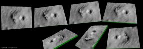
PSP_002922_1725-MF1-LXTT.jpgPossible Volcanic "Mouth", on Arsia Mons' Flank (High-Def Image Mosaic and Perspective Views - credits for the additional process.: Dr Marco Faccin)107 visitenessun commentoMareKromium
(8 voti)
|
|

PSP_002922_1725-MF2-LXTT.jpgPossible Volcanic "Mouth", on Arsia Mons' Flank (High-Def Image Mosaic - credits for the additional process.: Dr Marco Faccin)118 visitenessun commentoMareKromium
(8 voti)
|
|

ESP_014342_0930-10.jpgSouth Polar Residual Cap Intraseasonal Change Monitoring (EDM n.10 - Natural Colors; credits: Lunexit)74 visitenessun commentoMareKromium
(8 voti)
|
|
| 199 immagini su 17 pagina(e) |
2 | |
|
|
|
|
|
|
|
|
|
|
|








