| Piú votate - Mars through Mars Express (ESA - Original Raw Frames & Orbital Panoramas) |
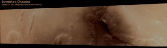
Chasmas-Juventae_Chasma-h0243_0000_nd3.jpgJuventae Chasma (Natural Colors, Tri-Chromatic Version - credits for the additional process. and color.: Dr Paolo C. Fienga - Lunexit Team)115 visitenessun commentoMareKromium
(7 voti)
|
|
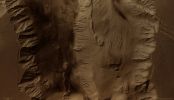
Chasmas-Candor_Chasma.jpgCandor Chasma (Natural Colors; credits: Lunexit)72 visitenessun commentoMareKromium
(7 voti)
|
|

South_Polar_Regions-Rupes_Tenuis-ESA-PF.jpgRupes Tenuis (possible Natural Colors; credits ESA - additional color. and process. Dr Paolo C. Fienga)88 visiteESA’s Mars Express orbiter imaged the snow-laden Region of Rupes Tenuis on the Martian North Pole on 29 July 2008.
Rupes Tenuis is located at the Southern Edge of the Martian North Polar Cap, approx. 5500 Km northeast of the Tharsis Volcanic Region.
The images are at about 81° north and 297° east and have a ground resolution of approx. 41 mt/pixel. They cover an area of about 44.000 square/Km, almost as large as the Netherlands.
Nota Lunexit: a nostro avviso questa "immagine" NON E' VERA! E' un disegno. Al limite, è la trasposizione digitale di un frame RAW originale unprocessed (ma ne dubitiamo).MareKromium
(7 voti)
|
|

Cydonia_Region-h3253_0000_s12-2.jpgDo you recognize this place? (natural colors; credits: Dr G. Barca & Lunexit)82 visiteUn semplice "Space-quiz": che Regione è quella che vedete in questo frame? Le Vostre risposte - motivate - possono essere inserite nei "Commenti".MareKromium
(7 voti)
|
|
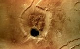
Craters-Unnamed_Crater_at_the_end_of_Mamers_Valles-392-250408-3304-6-co-01.jpgBird's-Eye view of Mamers Valles (MULTISPECTRUM; credits: Lunexit)122 visiteThe High-Resolution Stereo Camera (HRSC) onboard the ESA Spacecraft Mars Express obtained images focusing on a depression that displays a crater at the end of the long, winding Valley System known as Mamers Valles.
The data was obtained on 5 August 2006, with a ground resolution of approx. 14 mt/pixel. The image is centred at approx. 39° North and 17° East on the Planet.
The Mamers Valles System is approx. 1000 Km long, running along the boundary between the Northern Lowlands and Southern Highlands in the Region of Deuteronilus Mensae.
Scientists term a Region such as Mamers Valles ‘fretted terrain’ because it shows numerous deep and wide labyrinth-like valleys and circular depressions which often show structures formed by flowing liquid on their even floors. The structures formed by the flows are thought to be ice-rich debris flows. They show some resemblance to block glaciers seen on Earth.
The patches of rock at the centre of the depression are thought to be remnants of rock detached from the flanks of the depression and transported into its centre MareKromium
(7 voti)
|
|
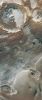
PrometheiPlanum.jpgPromethei Terra (Natural Colors + MULTISPECTRUM; credits: ESA & Lunexit)70 visitePromethei Planum, an area seasonally covered with layer of ice more than 3500 mt thick layer of ice in the Martian South Polar Region, was the subject of the High Resolution Stereo Camera’s focus on 22 September 2005 as Mars Express was in orbit above the Red Planet.
Promethei Planum lies at approx. 76° South Lat. and 105° East Long.
An approx. 100 Km-large and 800 mt-deep impact crater is visible in the Northern part of the image. The crater’s interior is partly covered in ice.
In the centre of the image are structures that may have been created by basaltic lava flow from a volcano. This area is covered in ice. The dark dunes towards the bottom of the image are most likely made up of dust originating from this lava flow or volcanic ash.
A broad sheet of ice, which is an extension of the South Polar Ice Cap is located South of the lava flow. The steep flanks clearly show white, clean ice. The thickness of the ice is between 900 and 1100 mt.MareKromium
(7 voti)
|
|
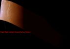
South_Polar_Regions-h0231_0000_nd3-01.jpgFrame Mars Express n. h0231_0000_nd3 (natural colors - elab. Lunexit)69 visite
(7 voti)
|
|

A-h0751_0000_bl2.jpgFrame Mars Express RAW n. h0751_0000_bl271 visite
(7 voti)
|
|
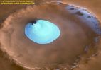
Craters-Lauth_Crater_in_Vastitas_Borealis_Region-Frozen_Lake-W-212-010705-1343-6-3d-01-00.jpgThe misterious "Frozen Lake" of Vastitas Borealis (1 - Natural Colors; credits ESA)84 visiteCaption ESA:"The HRSC on ESA's Mars Express obtained this perspective view on 2 February 2005 during orbit 1343 with a ground resolution of approximately 15 mt per pixel. It shows an unnamed impact crater located on Vastitas Borealis, a broad plain that covers much of Mars's far Northern Latitudes, at approx. 70,5° North Lat. and 103° East Long.
The crater is about 35 Km wide and has a maximum depth of approx. 2 Km beneath the crater rim. The circular patch of bright material located at the centre of the crater is residual water ice.
The colours are very close to natural, but the vertical relief is exaggerated three times. The view is looking East".
Nota: noi crediamo che questo cratere sia molto più enigmatico di quanto non appaia poichè, pur avendo esaminato tutti i frames NASA-MGS relativi alla Regione di Vastitas Borealis (in particolare quelli rapprsentativi dell'area suggerita dalle coordinate ESA), non ci è riuscito di individuare il "laghetto ghiacciato".
Il cratere senza nome che lo dovrebbe contenere, poi, appare solo una volta - e solo in una veduta PARZIALE! - in un frame NASA-Mars Odyssey che Vi proporremo qui di seguito.
Infine, i "colori naturali" di Vastitas Borealis, in accordo ai dati NASA disponibili (i quali sono anche comprensivi di informazioni ottenute sia attraverso vedute telescopiche HST, sia attraverso osservazioni effettuate da Terra), dovrebbero essere molto diversi da quelli suggeriti dall'ESA (noi Vi proporremo tre elaborazioni al riguardo).
(7 voti)
|
|
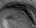
Volcanic_Features-Biblis_Patera-213-190705-1034-6-nd-01-BiblisP_H.jpgBiblis Patera (EDM - credits: ESA/DLR/FU Berlin (G. Neukum))73 visiteOriginal ESA caption:"This image taken by the High Resolution Stereo Camera (HRSC) on board ESA’s Mars Express spacecraft, shows the Biblis Patera Volcano, located in the Western part of the Tharsis rise on Mars.
The HRSC obtained this image on 8 November 2004 during orbit 1034 with a ground resolution of approx. 10,8 mt per pixel. Its shows the region of Biblis Patera at approx. 2,0° North and 236,0° East.
North is to the right".
(7 voti)
|
|

Volcanoes-Arsia_Mons_and_the_Tharsis_Montes-December_2012-PCF-LXTT-IPF-2.jpgOnce again...368 visiteE' divertente. Sempre lo stesso tipo di "nuvola", sempre lo stesso tipo di conformazione ed orientazione della stessa, sempre "in partenza" dal fianco superiore Sx del gigantesco Vulcano Arsia Mons e sempre interpretata come il frutto di semplici ed ovvi eventi atmosferici. Dalle immagini NASA - Viking - ottenute poco prima dell'inserzione orbitale, negli Anni '80 - ad un'altra serie di immagini ottenute ancora dalla Sonda ESA Mars Express nel 2008.
Questo il commentino ufficiale: "It's not a plume of smoke, but rather water ice clouds condensing out over the Summit of the Arsia Mons Volcano. We see them quite often over this particular volcano" - nota: la Scienziata è una tale Tanya Harrison - Planetary Scientist - NASA - Opportunity Rover Team).
Vi suggerisco, in un Mondo che va sempre più verso il "Pensiero Unico", di guardare questa immagine in correlazione agli altri (citati) eventi similari ed eclatanti occorsi, negli anni, sempre allo stesso posto. Non dubito (o forse si...) della competenza della Dott.ssa Harrison. Dubito della Sua (e non solo) perenne esternazione di certezze. Ecco. E questo atteggiamento, oltre ad irritarmi non poco, mi fa anche paura. Pensateci su. Magari guardando gli altri frames che possediamo e ragionando.
Nota: se doveste chiederVi come mai, di questo evento, parla una Scienziata Planetaria dell'Opportunity Rover Team e non chi se ne intende (davvero) di Vulcanologia e di Scienze Atmosferiche mentre l'ESA - come sempre o quasi fa - non ha detto un tubo, apprezzerei il quesito. Ma Vi dico subito che non saprei rispondere. O meglio: potrei! Ma rischierei la querela...MareKromium
(6 voti)
|
|

Volcanoes-Olympus_Mons_Caldera-1-015-090204_1-0037_01-6v-PCF-LXTT.jpgOlympus Mons' Caldera (Absolute Natural Colors; credits for the additional process. and color: Dr Paolo C. Fienga - Lunexit Team)233 visitenessun commentoMareKromium
(6 voti)
|
|
| 106 immagini su 9 pagina(e) |
 |
3 | |
|
|
|
|
|








