| Piú viste - From Ashes to Eternity: the Phoenix Mars Mission |

PHOE-SOL132-lg38854-38855-38856.jpgVastitas' Horizon - Sol 132 (Superdefinition and natural colors; credits: Dr G. Barca)68 visitenessun commentoMareKromium
|
|

PHOE-SOL134-lg39407-39408-39409-2.jpgThe Little (Man-Made) Mound near Phoenix - Sol 134 (Superdefinition and possible True Colors; credits: Dr G. Barca)68 visitenessun commentoMareKromium
|
|

PHOE-SOL137-lg39634-39635-39637-2.jpgMicroscopic Vastitas - Sol 137 (Superdefinition and possible True Colors; credits: Dr G. Barca & Lunexit)68 visitenessun commentoMareKromium
|
|

PHOE-SOL131-PIA11132.jpgDust Storm over Vastitas - Sol 131 (possible True Colors; credits: Lunexit)68 visitenessun commentoMareKromium
|
|

PHOE-SOL149-lg42169-42170-42171-2.jpgThe "Trenches" - Sol 149 (Superdefinition and possible True Colors; credits: Dr G. Barca)68 visitenessun commentoMareKromium
|
|
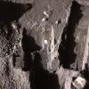
PHOE-SOL145-PIA11383.jpgThe "Trenches" - Sol 145 (False Colors; credits: NASA)68 visite...Tanto per far vedere la "differenza" fra il processing NASA e quello Lunexit...
Caption NASA:"The Surface Stereo Imager on NASA's Phoenix Mars Lander took this false color image on Oct. 21, 2008, during the 145th Martian Day, or Sol, since landing. The bluish-white areas seen in these trenches are part of an ice layer beneath the soil.
The trench on the upper left, called "Dodo-Goldilocks", is about 38 cm (15") long and 4 cm (1,5") deep.
The trench on the right, called "Upper Cupboard", is about 60 cm (24") long and 3 cm (1") deep. The trench in the lower middle is called "Stone Soup".MareKromium
|
|

PHOE-SOL059-lg15866-15867-15868-2_copia.jpgMineral Diversity in vastitas Borealis - Sol 59 (possible True Colors; credits: Dr G. Barca)68 visiteUna "risposta Lunexit" ai panorami monocromatici di Vastitas, "made by NASA"...MareKromium
|
|

PHOE-SOL020-lg5259-5260-5261-2_copia.jpgIce in the Trench - Sol 20 (True Colors; credits: Dr G. Barca & Lunexit)68 visitenessun commentoMareKromium
|
|

PHOE-SOL150-PIA12107.jpgComposite View of Phoenix Trenches (approx. True Colors; credits: NASA)68 visitenessun commentoMareKromium
|
|
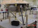
A-Phoenix-001.jpgThe Phoenix Lander: Hot-Fire Test Mock-Up67 visitenessun commentoMareKromium
|
|
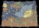
B-PIA09946-2.jpgPossible Landing Ellipses for Phoenix (2)67 visitenessun commentoMareKromium
|
|

B-PIA09946-1.jpgPossible Landing Ellipses for Phoenix (1)67 visiteCaption NASA:"Launch date makes a difference in the orientation of ellipses marking where NASA's Phoenix Mars Lander will have a high probability of landing, given the planned targeting for the Spring 2008 Landing Site. This map shows possible landing ellipses for the Aug. 3, 2007, opening of the launch period (the ellipse oriented North-West to South-East) and for launch dates at the middle and end of the 3-week period of launch opportunities.
The map also shows a color-coded interpretation of geomorphic units -- categories based on the surface textures and contours. The yellow-coded area surrounding a crater informally named "Heimdall" appears to have even fewer boulders on the surface than other units. The geomorphic mapping is overlaid on a shaded relief map based on data from the Mars Orbiter Laser Altimeter on NASA's Mars Global Surveyor orbiter.
The red box indicates the location of an image PIA09947 from the Context Camera on NASA's Mars Reconnaissance Orbiter".MareKromium
|
|
| 399 immagini su 34 pagina(e) |
 |
|
|
|
|
19 | |
|
|
|
|








