| |

|
|
|
|
|
|
|
|
|
|
|
|
| 20 album su 2 pagina(e) |
2 |
|
| Immagini a caso - SOLAR SYSTEM |

LLO-ST_2539423137_v.jpgThe unbelievable surface of 25143-Itokawa (HR4 - possible natural colors; elab. Lunexit)71 visitenessun commentoMareKromium
|
|

Neptune-V2.pngCrescent Neptune (August 1989)448 visite(ANSA) - ROMA, 18 AGOSTO 2022 - Compie 45 anni la sonda Voyager 2, la più longeva dell'era spaziale.
Lanciata il 20 agosto 1977, la sonda ha superato i confini del Sistema Solare nel 2018 ed è ancora attiva nello Spazio Interstellare, dal quale ha recentemente inviato dati mai visti (vedi Nota 1). Con la sua gemella Voyager 1, lanciata 15 giorni più tardi, la Voyager 2 è la protagonista di una missione da record. Gestite dal Jet Propulsion Laboratory (Jpl) della Nasa, le due sonde sono anche messaggeri molto speciali, che stanno portando nello spazio interstellare un biglietto da visita della Terra e dei suoi abitanti: un disco placcato in oro progettato per durare oltre un miliardo di anni, che contiene le immagini e suoni della vita sul nostro pianeta, diagrammi di leggi scientifiche fondamentali e saluti in molte lingue.
Entrambe le Sonde Voyager hanno attraversato il Sistema Solare rincorrendosi, con la Voyager 1 che ha raggiunto Giove e Saturno prima della sua compagna, mentre la Voyager 2 è stata la prima e finora l'unica sponda ad avvicinarsi a Urano, nel 1986, e poi a Nettuno, nel 1989, inviando a Terra le prime immagini ravvicinate di quei pianeti lontani, Nel 2013 la Voyager 1 era stata la prima a inoltrarsi nello spazio interstellare, seguita sei anni dopo dalla sua gemella. "Entrambe le sonde continuano a inviare all'umanità osservazioni da territori inesplorati", osserva la vice-responsabile scientifica del progetto, Linda Spilker, del Jpl. Le due Voyager "continuano a fare scoperte soprendenti", ha aggiunto la responsabile della missione Suzanne Dodd. "Non sappiamo per quanto tempo ancora la missione proseguirà, ma siamo sicuri che continuerà a regalarci molte sorprese scientifiche" (vedi Nota 2).
Nota 1: quali?
Nota 2: quali?
Come al solito: sensazionalismo di portata, condito dal nulla. Bellissima immagine comunque. L'aura più luminosa e bluastra che copre la porzione Sx del frame potrebbe essere un effetto del Sole. Ma non ho info al riguardo.MareKromium
|
|

09-vg1_p21229c.jpgThe "Great Red Spot" of Jupiter (false colors)67 visitenessun commento
|
|

Io-Eruption on Tvashtar Catena-PIA02584_modest.jpgIo: eruption in Tvashtar Catena93 visiteThis pair of images taken by NASA's Galileo spacecraft captures a dynamic eruption at Tvashtar Catena, a chain of volcanic bowls on Jupiter's moon Io. They show a change in the location of hot lava over a period of a few months in 1999 and early 2000.
The image on the left uses data obtained on Nov. 26 and July 3, 1999, at resolutions of 183 meters (600 feet) and 1.3 kilometers (0.8 miles) per pixel, respectively. The red and yellow lava flow itself is an illustration based upon imaging data. The image on the right is a composite using a five-color observation made on Feb. 22, 2000, at 315 meters (1030 feet) per pixel.
These are among the most fortuitous observations made by Galileo because this style of volcanism is too unpredictable and short-lived to plan to photograph.
Short-lived bursts of volcanic activity on Io had been previously detected from Earth-based observations, but interpreting the style of volcanic activity from those lower-resolution views was highly speculative. These Galileo observations confirm hypotheses that the initial, intense thermal output comes from active lava fountains. Galileo's high-resolution observations of volcanic activity on Io have also confirmed other hypotheses based on earlier, low-resolution data. These include interpretations of slowly spreading lava flows at Prometheus and Amirani and an active lava lake at Pele. These tests of earlier hypotheses increase scientists' confidence in interpreting volcanic activity seen in low-resolution remote sensing data of Earth as well as Io. However, these data are still of insufficient resolution to adequately test the more quantitative models that have been applied to volcanic eruptions on Earth and Io.
These images also show other geologic features on Io, such as the scalloped margins of the plateau to the northeast of the active lavas. These margins appear to have formed by sapping, a process usually associated with springs of water. Liquid sulfur dioxide might be the fluid responsible for sapping on Io. A better understanding of sapping on Io will influence how scientists interpret similar features on Mars(where the viability of carbon dioxide or water as the sapping fluid remains controversial).
|
|

Tethys from Voyager2.jpgTethys, from Voyager 281 visiteCaption NASA originale:"Voyager 2 obtained this view of Saturn's moon Tethys on Aug.25 from a distance of 540.000 Km. It shows the numerous impact craters and fault valleys of a very ancient surface. Tethys itself is 1.090 km. (approx. 675 mi) in diameter and the great chasm seen at the top of this image extends about 1.700 Km (approx. 1.050 mi) halfway across the satellite. The largest impact crater visible here is 90 Km (approx. 55 mi) in diameter".
|
|
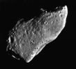
GASPRA-gal_p40449.jpgAsteroid 951-Gaspra (fly-by completed - b/w)62 visitenessun commento
|
|

Enceladus-N00030108.jpgEnceladus, from approx. 5.000 Km74 visitenessun commento
|
|

Saturn-HST-PIA05982_modest.jpgSaturn from Hubble Space Telescope73 visiteCaption NASA originale:"...The subtle pastel colors of ammonia-methane clouds trace a variety of atmospheric dynamics. Saturn displays its familiar banded structure, with haze and clouds at various altitudes. Like Jupiter, all bands are parallel to Saturn's equator. The magnificent rings, at nearly their maximum tilt toward Earth, show subtle hues which indicate the trace chemical differences in their icy composition..."
|
|
| Ultimi arrivi - SOLAR SYSTEM |
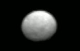
000-1-Ceres.gifCeres on sight (GIF-Movie)134 visiteIt is the largest asteroid in the asteroid belt - what secrets does it hold? To find out, NASA has sent the robotic Dawn Spacecraft to explore and map this cryptic 1,000-Km wide world: Ceres. Orbiting between Mars and Jupiter, 1-Ceres is officially categorized as a dwarf planet but has never been imaged in detail.
Featured here is a 20-frame video that rivals the best images of Ceres ever taken by the Hubble Space Telescope. The video shows enough surface definition to discern its 9-hour rotation period.
On target to reach 1-Ceres in early March, Dawn will match speeds and attempt to orbit this previously unexplored body, taking images and data that may help humanity better understand not only the nature and history of Ceres but also the early history of our entire Solar System.MareKromiumMag 23, 2026
|
|

ZZ-ZZ-ZZ-ZZ-ZZ-ZZ-ZZ-ZZ-Pluto-nh_01_stern_05_pluto_hazenew-PCF-LXTT-IPF-2.jpgA "Blue-rayed" Farewell to Pluto178 visiteNew Horizons is a NASA mission to study the dwarf planet Pluto, its moons, and other objects in the Kuiper Belt, a region of the solar system that extends from about 30 AU, near the orbit of Neptune, to about 50 AU from the Sun.
It was the first mission in NASA’s New Frontiers program, a medium-class, competitively selected, and principal investigator-led series of missions. (The program also includes Juno and OSIRIS-REx.)
New Horizons was the first spacecraft to encounter Pluto, a relic from the formation of the solar system. By the time it reached the Pluto system, the spacecraft had traveled farther away and for a longer time period (more than nine years) than any previous deep space spacecraft ever launched.
The design of the spacecraft was based on a lineage traced back to the CONTOUR and TIMED spacecraft, both also built by the Applied Physics Laboratory at Johns Hopkins University.
Besides its suite of scientific instruments, New Horizons carries a cylindrical radioisotope thermoelectric generator (a spare from the Cassini mission) that provided about 250 watts of power at launch (decaying to 200 watts by the time of the Pluto encounter).
After reaching initial Earth orbit at about 105 × 130 miles (167 × 213 kilometers), the Centaur upper stage fired (for a second time) for nine minutes to boost the payload to an elliptical orbit that stretched to the asteroid belt.
A second firing of the Star 48B solid rocket accelerated the spacecraft to a velocity of about 36,400 miles per hour (58,536 kilometers per hour), the highest launch velocity attained by a human-made object relative to Earth. The spacecraft was now set on a trajectory to the outer reaches of the solar system.
Controllers implemented course corrections on Jan. 28, Jan. 30, and March 9, 2006. A month later, on April 7, 2006, New Horizons passed the orbit of Mars.
A fortuitous chance to test some of the spacecraft’s instruments – especially Ralph (the visible and infrared imager and spectrometer) – occurred June 13, 2006, when New Horizons passed by a tiny asteroid named 132524 APL at a range of about 63,300 miles (101,867 kilometers).
The spacecraft flew by the solar system’s largest planet, Jupiter, for a gravity assist maneuver on Feb. 28, 2007, with the closest approach at 05:43:40 UT. The encounter increased the spacecraft’s velocity by about 9,000 miles per hour (14,000 kilometers per hour), shortening its trip to Pluto by three years.
During the flyby, New Horizons carried out a detailed set of observations over a period of four months in early 2007. These observations were designed to gather new data on Jupiter’s atmosphere, ring system, and moons (building on research from Galileo) and to test out New Horizon’s instruments.
Although observing the moons from distances much farther than Galileo, New Horizons was still able to return impressive pictures of Io (including eruptions on its surface), Europa, and Ganymede.
After the Jupiter encounter, New Horizons sped toward the Kuiper Belt, performing a course correction on Sept. 25, 2007.
The spacecraft was put in hibernation mode starting June 28, 2007, during which time the spacecraft’s onboard computer kept tabs on mission systems, transmitting special codes indicating that operations were either nominal or anomalous. During hibernation, most major systems of New Horizons were deactivated and revived only about two months every year. The second, third, and fourth hibernation cycles were Dec. 16, 2008, Aug. 27, 2009, and Aug. 29, 2014.
New Horizons passed the halfway point to Pluto on Feb. 25, 2010.
The discovery of new Pluto moons Kerberos and Styx during the mission added to concerns that there might be debris or dust around Pluto. Mission planners devised two possible contingency plans in case debris increased as the spacecraft approached Pluto, either using its antenna facing the incoming particles as a shield or flying closer to Pluto where there might be less debris.
On Dec. 6, 2014, ground controllers revived New Horizons from hibernation for the last time to initiate its active encounter with Pluto. At that time, it took four hours and 25 minutes for a signal to reach Earth from the spacecraft.
The spacecraft began its approach phase toward Pluto on Jan. 15, 2015, and its trajectory was adjusted with a 93-second thruster burn on March 10. Two days later, with about four months remaining before its close encounter, New Horizons finally became closer to Pluto than Earth is to the Sun.
Pictures of Pluto began to reveal distinct features by April 29, 2015, with detail increasing week by week into the approach. A final 23-second engine burn on June 29, 2015, accelerated New Horizons toward its target by about 11 inches per second (27 centimeters per second) and fine-tuned its trajectory.
There was concern on July 4, 2015, when New Horizons entered safe mode due to a timing flaw in the spacecraft command sequence. Fortunately, the spacecraft returned to normal science operations by July 7.
Three days later, data from New Horizons was used to conclusively answer one of the most basic mysteries about Pluto: its size. Mission scientists concluded that Pluto is about 1,470 miles (2,370 kilometers) in diameter, slightly larger than prior estimates. Its moon Charon was confirmed to be about 750 miles (1,208 kilometers) in diameter.MareKromiumMag 20, 2026
|
|
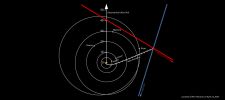
ZZ-ZZ-ZZ-ZZ-ZZ-Z-New_Horizons_Proxima-2025_28129_gifH_Interstellar_v2.jpgInterstellar Navigation113 visiteSince its launch in 2006, New Horizons has been on a trajectory that brought it past Pluto and then Kuiper Belt object Arrokoth and will eventually take it out of the solar system, into interstellar space over the next decade. In 2020, the New Horizons science team, in an effort led by Lauer, obtained images of the star fields around the nearby stars Proxima Centauri and Wolf 359 simultaneously from New Horizons and Earth. This program vividly demonstrated New Horizons’ change in perspective as it ventured from the inner to the outer solar system.
But more recent and sophisticated analyses of the exact positions of the two stars in those 2020 images allowed Lauer, working with retired Lawrence Livermore National Laboratory researcher David Munro, as well as members of the New Horizons team and external collaborators, to deduce New Horizons’ three-dimensional position relative to nearby stars – accomplishing the first use of stars imaged directly from a spacecraft to provide its navigational fix, and the first demonstration of interstellar navigation by any spacecraft on an interstellar trajectory.
A paper describing the results was accepted for publication in The Astronomical Journal. The preprint is available on the server arXiv.
“This pioneering interstellar navigation demonstration and its accompanying publication show that a deep-space mission can use its onboard imaging system to find its way among the stars,” said Alan Stern, principal investigator for New Horizons from the Southwest Research Institute in Boulder, Colorado. “While for New Horizons, this method isn’t as accurate as NASA’s sophisticated tracking from Earth, it could be highly useful for future deep space missions in the far reaches of the solar system and in interstellar space.”MareKromiumMag 20, 2026
|
|
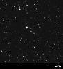
ZZ-ZZ-ZZ-ZZ-ZZ-Z-New_Horizons_Proxima-2025_28129.gif132 visiteWhile spacecraft can use stars to get a sense of direction, figuring out how far and where a spacecraft has traveled from home usually requires accurate radio tracking from Earth. But members of NASA’s New Horizons team – using the mission’s spacecraft, now more than five billion miles from Earth – have demonstrated for the first time that it’s possible to determine direction and distance just by examining images the spacecraft snaps of star fields.
“As a spacecraft travels deeper into space, the positions of the stars seen from its location begin to shift from where they are seen from Earth,” explained Tod Lauer, an astrophysicist and New Horizons science team member from the National Optical-Infrared Astronomy Research Laboratory in Tucson, Arizona. “A spacecraft voyaging out into the Milky Way can measure these shifts, due to an effect called parallax, to locate where it is with respect to nearby stars. New Horizons has traveled far enough away that it can provide the first true demonstration of interstellar navigation.”MareKromiumMag 20, 2026
|
|

3I-ATLAS_noise_or_signal.mp33I/Atlas says "Hi!"165 visiteMaking a comment, I believe it's just useless. Enjoy it, anyway!MareKromiumMag 16, 2026
|
|
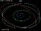
Asteroid_-_Donaldjohanson_P_Lucy_s_trajectory_around_Sun.gifLucy's race (GIF-Movie)140 visiteDonaldjohanson was visited by the Lucy Spacecraft that was launched on 16 October 2021. The Fly-By took place on 20 April 2025, with a closest approach distance of approx. 960 Km (about 600 mi) at a relative velocity of 13.4 Km (8.3 mi) per second.MareKromiumMag 12, 2026
|
|
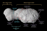
Asteroid_-_Donaldjohanson_Offical_Names.pngAsteroid Donaldjohanson (nomenclature)167 visiteOn 27 August 2025, the International Astronomical Union announced 11 official names for Geological Features on Donaldjohanson, which follow the naming theme of archeological sites and hominin fossils. The smaller lobe of Donaldjohanson is named Afar Lobus, after the Afar Triangle in Ethiopia, and the larger lobe is named Olduvai Lobus, after Olduvai Gorge in Tanzania.
The neck connecting the two lobes is named Windover Collum, after the Windover Archeological Site in Florida, United States. The middle of Windover Collum is encircled by a ridge named Luzia Dorsum (named after the Luzia Woman), which divides the neck into Hadar Regio and Minatogawa Regio (named after Hadar, Ethiopia and the Minatogawa Man, respectively). Several craters and large boulders ("saxa") on Olduvai Lobus have been named as well.MareKromiumMag 12, 2026
|
|
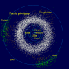
000-Asteroids_-_Main_Belt.pngAsteroid Belt142 visiteThe Asteroid Belt is a torus-shaped region in the Solar System, centered on the Sun and roughly spanning the space between the orbits of the planets Jupiter and Mars. It contains a great many solid, irregularly shaped bodies called asteroids or minor planets. The identified objects are of many sizes, but much smaller than planets, and, on average, are about one million kilometers (or six hundred thousand miles) apart. This asteroid belt is also called the main asteroid belt or main belt to distinguish it from other asteroid populations in the Solar System.
The Asteroid Belt is the innermost and smallest circumstellar disc in the Solar System. Its total mass is estimated to be 3% that of the Moon, with about 60% contained in the four largest asteroids: Ceres, Vesta, Pallas, and Hygiea. Classes of small Solar System bodies in other regions are the near-Earth objects, the Centaurs, the Kuiper Belt Objects, the scattered Disc Objects, the Sednoids, and the Oort Cloud Objects.MareKromiumMag 12, 2026
|
|
|
|